
Philadelphia Snow Chances Climb as Coastal Storm Strengthens Offshore, Models Hint at Overnight “Thump” Sunday Into Monday
PHILADELPHIA, PENNSYLVANIA — A developing coastal storm system is drawing growing attention from forecasters as updated weather models suggest increasing odds that the northern edge of the system could deliver a quick burst — or “thump” — of snowfall around Philadelphia overnight Sunday into Monday morning.
While much of the storm’s energy remains offshore, subtle shifts in track and intensity are raising the possibility that southeastern Pennsylvania could be clipped by the system’s northern precipitation shield.
Coastal Low Strengthens Off the Mid-Atlantic Coast
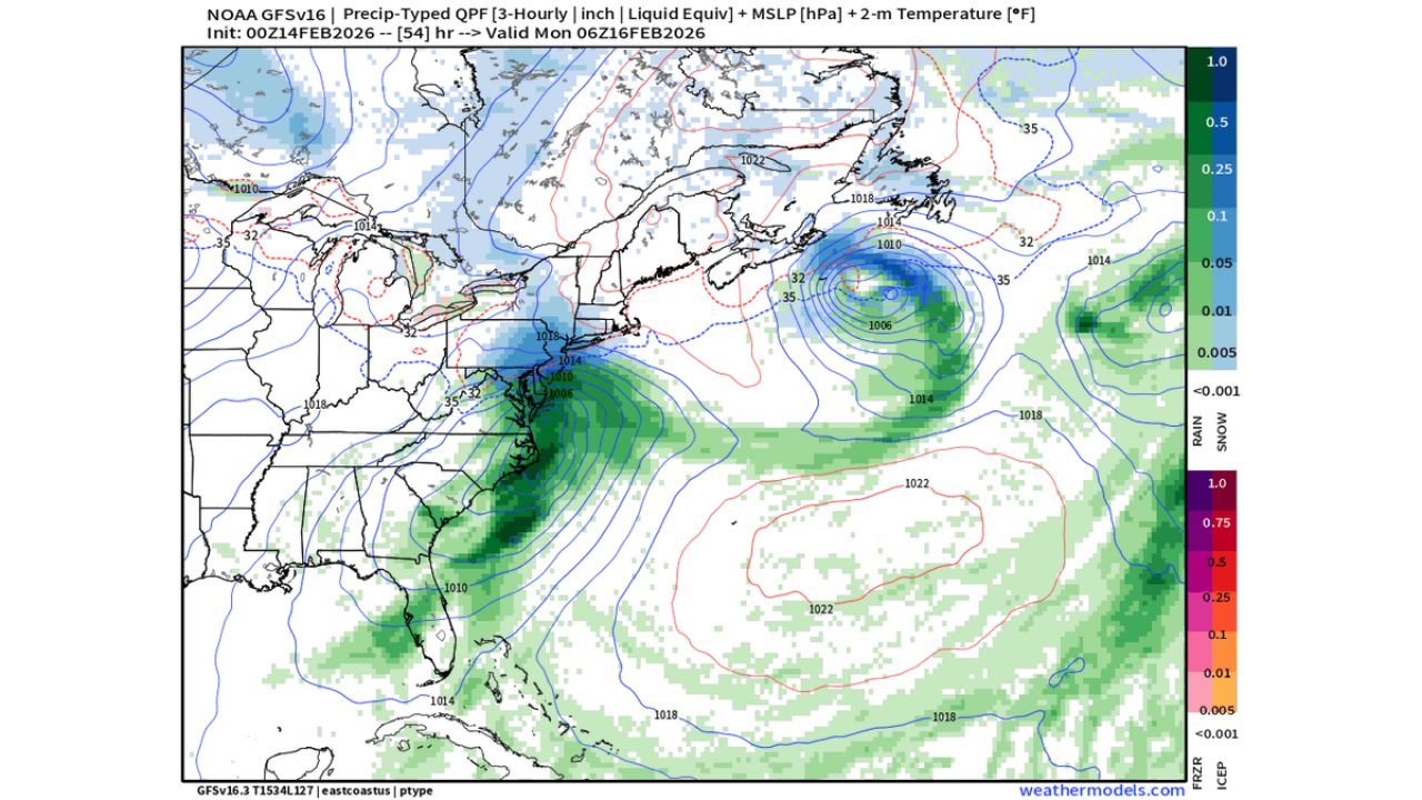
Latest model guidance shows a deepening low-pressure system consolidating near the Carolina coastline before tracking northeastward into the western Atlantic. Upper-level wind maps indicate a strong circulation centered near eastern North Carolina, with tightening pressure gradients and strengthening winds over the Atlantic waters.
By early Monday morning, the system appears well-organized offshore of the Delmarva Peninsula and the New Jersey coast, with precipitation wrapping around the western flank of the storm.
The storm’s most intense rainfall and wind remain offshore, but the northern fringe of the precipitation shield edges toward southern New Jersey, Delaware, and southeastern Pennsylvania.
Snow Potential Hinges on Northern Edge Placement
Precipitation-type model projections valid around 1 a.m. to 6 a.m. Monday show rain dominating across the coastal Carolinas and much of the offshore waters. However, near the I-95 corridor from Baltimore to Philadelphia, temperatures hover close to the freezing mark.
Surface temperature guidance suggests readings near 32 to 35 degrees in the Philadelphia area overnight. That marginal setup means precipitation intensity could play a key role.
If the northern edge of the precipitation shield shifts just slightly farther north, Philadelphia could experience a brief but moderate burst of snow, particularly during the pre-dawn hours Monday. This type of setup — where strong lift briefly overcomes marginal temperatures — is often referred to as a “thump” snowfall.
Areas farther north into Allentown and northern New Jersey may remain largely dry if the storm tracks slightly offshore.
Track and Timing Remain Critical
The exact track of the coastal low remains the deciding factor. A jog 25 to 50 miles farther west could increase snowfall potential across Philadelphia and surrounding suburbs. Conversely, a slightly more offshore solution would keep the accumulating snow south and east of the city.
Current projections place the heaviest precipitation closer to southern New Jersey and coastal Delaware, with lighter amounts brushing southeastern Pennsylvania.
Model pressure fields show the storm center remaining offshore, which generally favors lighter precipitation inland. However, the northern deformation band — the zone capable of producing heavier snow — may briefly pivot toward the city if the storm intensifies quickly enough.
What Philadelphia Residents Should Expect
At this time, the most likely scenario includes:
- Cloudy conditions Sunday evening
- Precipitation developing late Sunday night
- A rain-to-snow mix possible before daybreak Monday
- Potential for a brief accumulation if rates intensify
Any snowfall would likely occur during the early morning hours, potentially affecting the Monday commute if it materializes.
Given marginal temperatures, accumulation would depend heavily on snowfall intensity and surface conditions. Roads that remain warm may limit sticking, but grassy and elevated surfaces could see a coating.
Growing Excitement, But Still Uncertainty
Forecasters describe the setup as one that bears close watching rather than one that guarantees a widespread event. The “excitement” comes from increasing model consistency in showing precipitation brushing the region — a change from earlier runs that kept the system well offshore.
As the storm approaches, additional model cycles will refine snowfall potential and clarify how far north the precipitation shield ultimately reaches.
For now, residents of Philadelphia and southeastern Pennsylvania should stay tuned for updates as the coastal storm evolves.
For continued coverage of Mid-Atlantic weather systems, snow potential updates, and coastal storm tracking, visit ChicagoMusicGuide.com for the latest forecast analysis.