
Record-Breaking Arctic Blast Forecast to Drive Temperatures 40–50 Degrees Below Normal Across Wisconsin and Minnesota This Weekend
MADISON, WISCONSIN — A dangerously strong Arctic blast is forecast to sweep across Wisconsin and Minnesota this weekend, with meteorologists warning that temperatures could plunge 40 to 50 degrees below average on Saturday morning — potentially setting new December cold-weather records across the Upper Midwest.
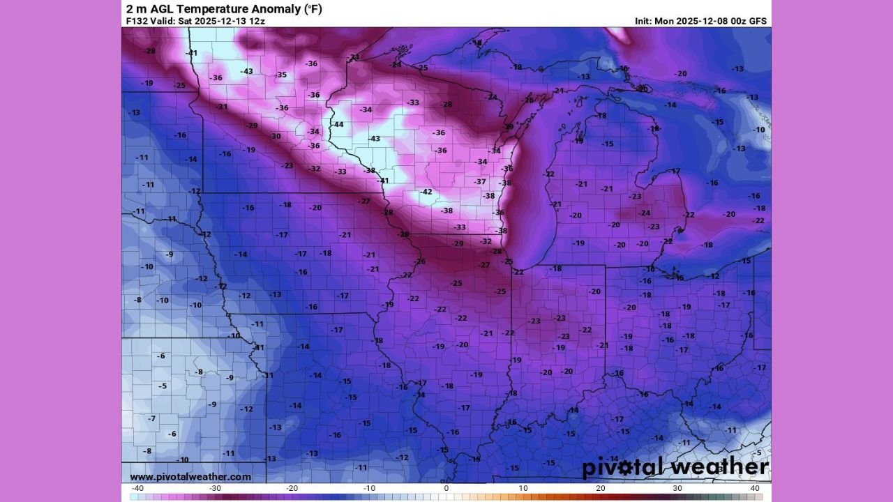
High-resolution GFS model data shows a massive dome of polar air sinking south, delivering widespread subzero temperatures and some of the coldest anomalies seen in years.
A Rare December Temperature Crash for the Upper Midwest
Latest forecast maps reveal temperature anomalies ranging from –30°F to –38°F across central and northern Minnesota, with western Wisconsin showing similarly extreme departures from normal.
The core of the cold appears centered directly over:
- Northern Minnesota: anomalies approaching –40°F to –43°F
- Central Minnesota and Northwest Wisconsin: –34°F to –38°F
- Southern Wisconsin: widespread –18°F to –25°F
Meteorologists note that the region could experience the coldest mid-December outbreak since the early 1990s, with the potential for historic readings if skies clear overnight.
Saturday Morning Could Bring Dangerous Subzero Lows
Forecast trends indicate:
- Northern MN: –15°F to –25°F
- Central MN: –10°F to –20°F
- Northern WI: –10°F to –18°F
- Southern WI: –5°F to –12°F
Wind chills may range from –25°F to –40°F, especially across open rural terrain.
This level of Arctic intrusion — showing 50 degrees below climatological averages in some corridors — is extremely unusual for early December and signals a deep north-to-south jet pattern driving frigid air directly out of the Canadian Arctic.
Why This Arctic Blast Is So Severe
Meteorologists highlight several contributing factors:
- A strong polar vortex disturbance funneling cold southward
- Intensifying high-latitude blocking near Greenland
- A deep trough carved directly over Wisconsin and Minnesota
- Snow cover already enhancing surface cooling
This combination creates conditions where temperatures can crash rapidly and stay well below freezing for extended periods.
Impacts Across Wisconsin and Minnesota
Residents are urged to prepare for:
- Hazardous wind chills
- Frozen pipes in poorly insulated structures
- Potential school delays or closures
- Dangerous road conditions as any moisture refreezes
- High demand on heating systems
Emergency management officials recommend checking on neighbors, especially the elderly or those without reliable heat sources.
Music & Community Event Advisory
With performances, rehearsals, and winter shows scheduled across both states, venues and musicians should anticipate:
- Earlier load-in challenges
- Equipment temperature-sensitivity issues
- Reduced audience turnout if travel becomes hazardous
Cold surges of this magnitude can disrupt weekend performances and outdoor setups, especially in northern touring routes.
What’s Next?
Long-range data suggests the Arctic air may linger, with additional reinforcing cold shots possible mid-next week. Meteorologists will refine temperature projections as the system evolves through Friday.
Stay connected for updates and artist-community alerts at ChicagoMusicGuide.com.