
Severe Storms and Snow Threat Stretch From Oklahoma and Texas to Illinois, Mississippi, and Alabama as Multi-Day System Intensifies
UNITED STATES — A powerful multi-day storm system is setting up across the central and eastern United States, bringing a combination of severe thunderstorms, damaging winds, isolated tornadoes, and a late-stage snow threat from Texas and Oklahoma through Illinois, Mississippi, Alabama, and the Great Lakes region between Wednesday and Friday.
Forecast data shows this system evolving rapidly as it tracks east, with changing hazards depending on location and timing.
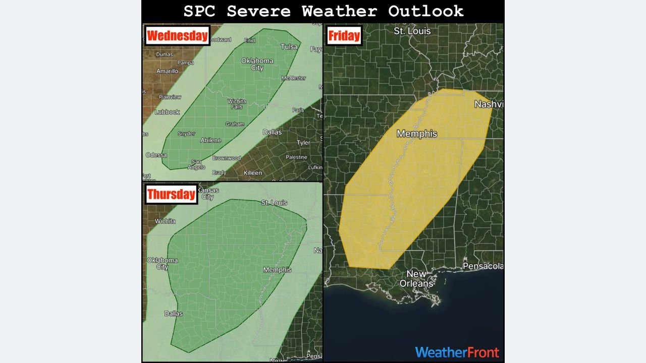
Wednesday: Marginal Severe Risk Develops Across Oklahoma and North Texas
On Wednesday, the Storm Prediction Center has introduced a Marginal Risk (Level 1 of 5) for severe weather stretching from northern Oklahoma into parts of west and north Texas.
Most storms during this phase are expected to develop after dark and remain elevated, meaning they may not fully tap surface-based instability. As a result:
- Isolated large hail
- Localized damaging wind gusts
are the primary concerns, while tornado potential remains very low during this stage.
Thursday: Conditional Severe Threat Expands Into the Southern Plains and Mid-South
By Thursday, the risk zone expands eastward across Texas, Oklahoma, Arkansas, Missouri, and parts of the Mid-South, though instability remains imperfect.
Forecast guidance indicates storms may struggle initially due to limited surface instability. However, any storms that do develop could still produce low-end severe impacts, including:
- Strong wind gusts
- Isolated hail
- Brief, embedded circulations
This phase is considered conditional, meaning coverage and intensity depend heavily on how quickly storms can organize.
Friday: Widespread Severe Storm Risk From Louisiana to Tennessee
Friday is the most concerning day of this multi-day setup.
The Storm Prediction Center has maintained a Slight Risk (Level 2 of 5) for widespread severe weather from Louisiana and Mississippi northward into Tennessee and parts of the Ohio Valley, including southern Illinois.
Forecast data suggests storms will quickly organize into a fast-moving squall line, increasing the risk for:
- Widespread damaging wind gusts
- Power outages
- Tree damage
- A few embedded tornadoes (EF0–EF2), especially across Mississippi and western Alabama
Discrete supercells are expected to be limited, but the overall wind threat will be significant.
Back-Side Cold Air May Flip Rain to Snow in the Midwest and Great Lakes
As the storm system lifts northeast late Friday into Saturday, colder air wrapping in behind the system could cause rain to change over to snow across portions of the Great Lakes and Upper Midwest, including Illinois, Wisconsin, Michigan, and northern Indiana.
Some forecast guidance is modeling snowfall totals of up to 8 inches in localized areas, though final accumulations will depend heavily on last-minute temperature trends and storm track adjustments.
This introduces the possibility of travel disruptions after the severe weather threat ends farther south.
What to Watch Closely
- Strong winds along the Friday squall line
- Localized tornado potential in Mississippi and Alabama
- Late-season snow accumulation in the Great Lakes region
- Rapid weather changes over short distances
Residents across multiple states should remain weather-aware and prepared for changing conditions.
Stay connected with Chicagomusicguide.com for continued weather updates, safety information, and detailed breakdowns as this multi-day storm system unfolds.