
Sneaky Weekend Snow Threat Targets New York, Massachusetts, Rhode Island, New Jersey, and Pennsylvania With Narrow Heavy Bands
UNITED STATES — A deceptively tricky winter setup is taking shape for the Eastern United States this weekend, with forecast models signaling a high-impact but narrow snow threat that could surprise parts of New York, Massachusetts, Rhode Island, New Jersey, and Pennsylvania. While this will not be a widespread blockbuster storm, the ingredients are lining up for localized plowable snowfall, including isolated 6+ inch totals and even pockets near 8 inches where banding locks in.
Why This Weekend’s Snow Setup Is So Tricky
Meteorologists are closely watching a compact but intense upper-level system, visible clearly on ECMWF 500-mb height and vorticity maps. The system features a strong, negatively tilted trough digging into the Eastern U.S., creating an environment favorable for high snow ratios.
That means snowfall totals could quickly stack up without needing much moisture. In this setup, less than half an inch of liquid (QPF) could still translate into several inches of snow, especially where lift is maximized.
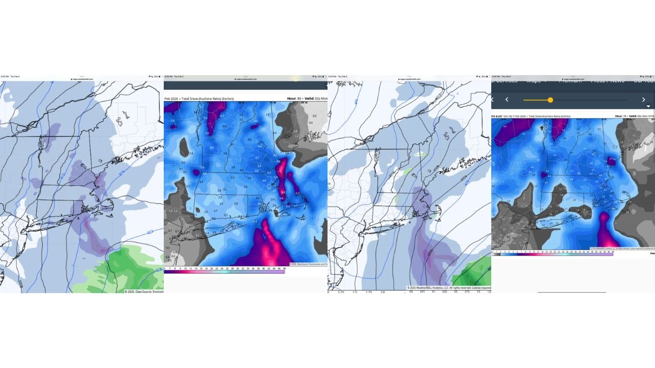
Inverted Trough Placement Will Decide Who Gets Hit Hardest
The biggest forecast question remains where the inverted trough sets up on Saturday — a detail that will determine who ends up under the heavier snow band.
- The 18z RGEM places the trough axis closer to Rhode Island
- The 18z GFS shifts it slightly north into eastern Massachusetts
This difference may sound minor, but it’s critical. The heavy band is expected to be only 15–20 miles wide, meaning a small shift could be the difference between a light snowfall and a 3–5 inch localized event.
Snowfall Expectations Across Southern New England
For most of Southern New England, current guidance supports a general 1–3 inch snowfall. However, embedded within that broader zone is the potential for narrow but intense banding.
Where that band stalls:
- Snowfall rates could briefly become moderate to heavy
- Totals could reach 2–4 inches, with isolated 3–5 inch pockets
- Snow could accumulate quickly despite short duration
Eastern Massachusetts and Rhode Island remain the most favored locations for this higher-end outcome based on current guidance.
Additional Areas to Watch Closely
Beyond the core Southern New England zone, accumulating snow is also possible in:
- Upstate New York, where colder air supports higher ratios
- Long Island, New York, especially central and eastern sections
- Coastal New Jersey, including the Jersey Shore, where coastal convergence may enhance snowfall
- Parts of eastern Pennsylvania, depending on final track and band placement
These areas may not all see heavy totals, but accumulating and plowable snow remains firmly on the table.
High Snow Ratios Raise the Ceiling
One of the standout signals in the data is the presence of very high snow ratios, confirmed by Kuchera output and thermal profiles. This setup favors fluffier, more efficient snow, meaning totals can outperform liquid equivalents.
In simple terms:
It won’t take much precipitation to create notable snowfall.
That’s why forecasters are stressing caution despite relatively modest QPF values.
Not a Widespread Storm — But a High-Impact One for Some
This will not be a region-wide shutdown, but for communities that fall under the heavier band, this will feel like a legitimate winter storm. The uncertainty is not if accumulating snow occurs — it’s exactly where the axis sets up.
As one forecaster put it, “This is super sneaky — but it’s going to be fun to track.”
What Happens Next
Confidence will improve as higher-resolution guidance locks in the final placement of the inverted trough. Updated snowfall maps are expected as the event draws closer, and subtle shifts remain likely.
Residents across New York, Massachusetts, Rhode Island, New Jersey, and Pennsylvania should stay alert for updates, especially if they fall near the coastal and eastern New England corridor.
Want more detailed storm breakdowns, map analysis, and real-time winter weather updates? Follow along at Chicagomusicguide.com and stay ahead of the next surprise system.