
Southern Plains, Lower Mississippi Valley, Midwest, and Northeast Face Catastrophic Ice and Snow as Major January Winter Storm Intensifies
UNITED STATES — A massive and dangerous January winter storm continues to intensify across a broad swath of the country, stretching from the Southern Plains and Lower Mississippi Valley through the Midwest, Ohio Valley, Mid-Atlantic, and Northeast. According to the Weather Prediction Center (WPC), the storm is producing widespread heavy snow, crippling sleet, and destructive freezing rain, with impacts expected to last well into next week due to lingering extreme cold.
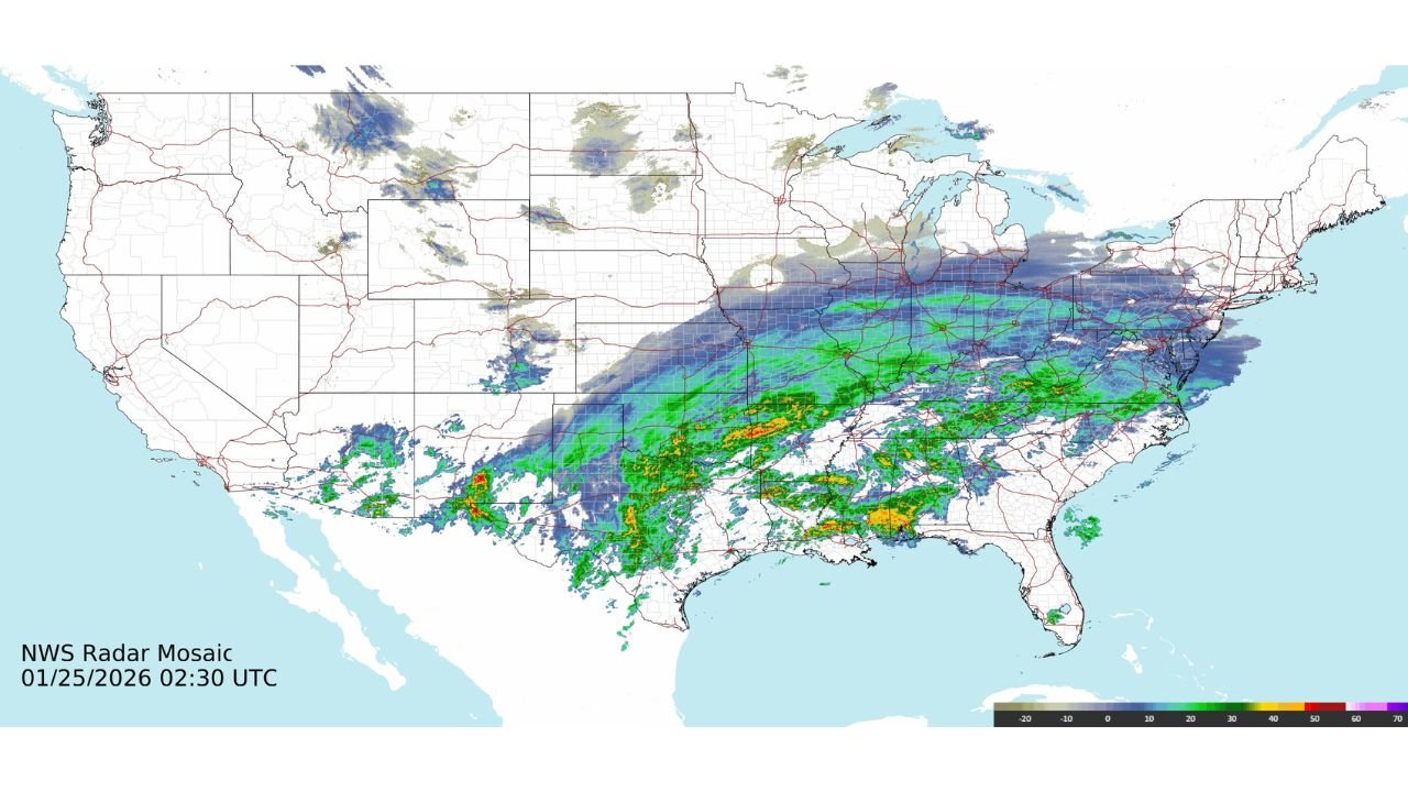
Radar imagery early Sunday shows a continuous band of wintry precipitation arcing from Texas and Oklahoma northeastward through Arkansas, Tennessee, Kentucky, Ohio, and into the Northeast, while Arctic air continues pushing south behind the system.
Heavy Snow Piles Up From the Plains to the Northeast
On the northern side of the storm, heavy snow has already accumulated across portions of the Southern Rockies, Plains, Midwest, and Ohio Valley, with snowfall expanding eastward into the Mid-Atlantic and New England.
Preliminary snowfall totals highlight the storm’s intensity:
- Colorado: Up to 23 inches near Crested Butte, with mountain passes exceeding 8–11 inches
- Kansas: Widespread 6–8 inches, including near Wichita and Manhattan
- Arkansas: Several locations near 7–8 inches
- Oklahoma and Tennessee: Many areas reporting 4–7 inches
- New Mexico: Mountain and northern areas seeing 9–13 inches
Forecast guidance indicates that maximum snowfall totals exceeding one foot remain likely from parts of the Southern Plains through the Mid-Atlantic and into the Northeast, especially where snow remains dominant throughout the event.
Severe Sleet Corridor Creates Extreme Travel Hazards
South of the heaviest snow axis, a high-impact sleet zone has developed, producing 1 to over 3 inches of sleet across parts of:
- North Texas
- Southern Oklahoma
- Arkansas
- Louisiana
- Mississippi
- Western Tennessee
Sleet accumulations of this magnitude are especially dangerous, creating concrete-like road conditions that are nearly impossible to treat. Travel disruptions in these regions are expected to last multiple days, even after precipitation ends.
Destructive Ice Accretion Threatens Power Grid and Infrastructure
Perhaps the most dangerous aspect of this storm is the widespread freezing rain, which is producing significant ice accretion across large portions of the Southern Plains, Lower Mississippi Valley, Tennessee Valley, Southeast, and southern Appalachians.
Reported ice totals already include:
- Texas: Up to 0.50 inches, with localized higher amounts
- Louisiana: Up to 0.75 inches
- Mississippi: Widespread 0.25 inches, with pockets approaching 0.50 inches
- Oklahoma, Tennessee, North Carolina: Ice totals ranging from 0.10 to 0.50 inches
Forecasters warn that catastrophic impacts are likely where ice exceeds one-half inch, including:
- Long-duration power outages
- Extensive tree and power line damage
- Extremely dangerous or impassable roads
In some locations, locally over one inch of ice accumulation remains possible, particularly across northern Louisiana, central and northern Mississippi, southern Tennessee, and the southern Appalachian region.
Extreme Cold Prolongs Impacts Well Into Next Week
Behind the storm, bitter Arctic air is settling across much of the country. Temperatures in the single digits and teens have already been observed from the Southern Plains to the Mid-Atlantic, with wind chills driving conditions even lower.
This prolonged cold will:
- Slow power restoration efforts
- Delay road clearing
- Increase the risk of frozen pipes
- Extend hazardous travel conditions
Officials warn that cleanup efforts will be severely hampered, prolonging infrastructure damage and community impacts through at least early next week.
What Happens Next
The Weather Prediction Center expects additional snow, sleet, and freezing rain to continue through Monday as the upper-level system tracks eastward. Winter Storm Warnings, Ice Storm Warnings, Extreme Cold Warnings, and Cold Weather Advisories remain in effect across a vast portion of the country.
Residents across impacted regions are urged to avoid travel, prepare for extended power outages, and follow guidance from local emergency management and National Weather Service offices.
For continued coverage of this major winter storm, regional impact breakdowns, and ongoing weather updates across the United States, visit ChicagoMusicGuide.com.