Texas, Louisiana, Mississippi, Alabama, Georgia, and the Carolinas Face Potentially Crippling Ice Storm and Heavy Snow This Weekend

UNITED STATES — A rare and potentially historic winter storm is taking shape for late January, with Texas, Louisiana, Mississippi, Alabama, Georgia, North Carolina, and South Carolina all within a high-risk zone for crippling ice, widespread power outages, and dangerous travel from Friday through Sunday. Forecast confidence continues to increase that this system could become one of the most disruptive winter storms many parts of the South and Southeast have experienced in years.
Why This Winter Storm Is So Concerning
This setup features a powerful surge of Arctic air pushing unusually far south at the same time deep Gulf moisture rides north over that cold surface layer. This combination is notorious for producing long-duration freezing rain, which is far more damaging than snow in much of the South.
Meteorologists stress that Arctic air masses are often undermodelled, meaning freezing temperatures may reach farther south than current projections — increasing the threat of ice in areas that rarely see storms of this magnitude.
High-End Ice Storm Risk From Texas to the Carolinas
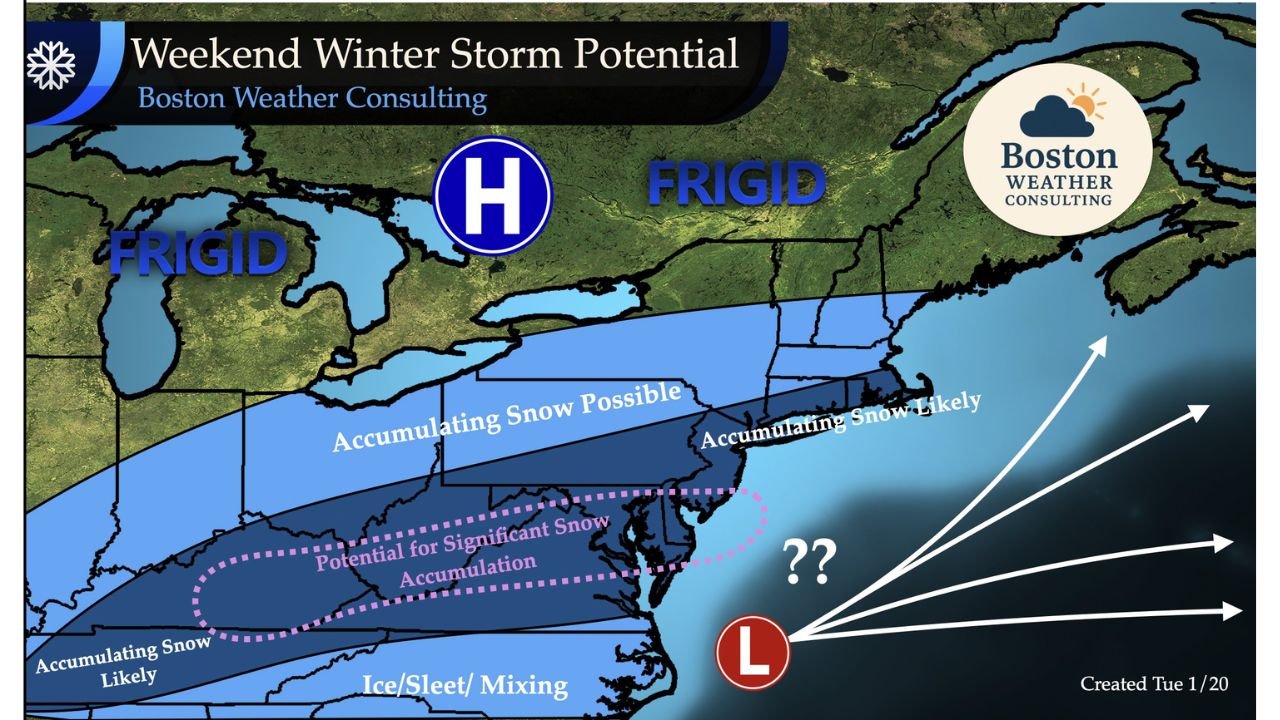
Impact maps now consistently show a dangerous corridor stretching from North and Central Texas through Louisiana, Mississippi, Alabama, Georgia, and into the Carolinas, where freezing rain and sleet could dominate.
Some guidance suggests 0.5 to 1.25 inches of ice accretion is possible in parts of this zone if worst-case scenarios verify. Ice amounts at this level can result in:
- Widespread, prolonged power outages
- Tree limbs and power lines snapping under heavy ice
- Roads becoming impassable for days
- Severe damage to vegetation and infrastructure
Cities from Dallas to Atlanta to Charlotte could see major disruptions, particularly in areas without widespread access to backup power.
Heavy Snow Adds Another Layer of Impact
North of the ice zone, a broad west-to-east band of heavy snow is increasingly likely. Forecast signals point to 6–12 inches of snow, with locally higher totals possible across parts of the Tennessee Valley, southern Appalachians, and interior Mid-Atlantic.
In higher elevations — especially across western North Carolina — snowfall totals could reach double-digit inches, raising concerns about:
- Snow-covered and drifted roadways
- Reduced visibility and hazardous travel
- Additional strain on already vulnerable power infrastructure
Timing: Friday Through Sunday Looks Especially Dangerous
While exact precipitation types will continue to shift over the next few days, confidence is high that Friday through Sunday will be extremely rough across much of the eastern United States.
Forecasters emphasize this is not a last-minute event — small temperature changes could dramatically alter whether a location sees snow, sleet, or crippling ice.
Why Forecasters Are Using Strong Language
Meteorologists rarely describe a storm as crippling this far in advance, but many note they haven’t seen signals like this since the major winter storms of 2017 and 2018. Those events caused week-long power outages and long recovery periods, particularly in the South.
Adding to concern, this storm may be followed by another surge of Arctic air, with the potential for record-challenging cold reaching deep into the Southeast, possibly even Florida.
What Residents Should Do Now
Preparation should begin immediately in high-risk areas:
- Plan for extended power outages
- Secure alternative heat sources
- Stock up on food, water, and medications
- Check on elderly family members and neighbors
- Avoid travel once conditions deteriorate
This developing winter storm has the potential to be one of the most memorable January weather events in years for the South and Southeast. Forecasts will be refined daily, but the message is already clear: this is a storm to take seriously.
Stay updated and prepared with continued coverage from ChicagoMusicGuide.com as this high-impact winter system approaches.
