
Texas, Mississippi, Alabama, and Tennessee Face Moderate Flood Risk as Widespread Heavy Rain Targets the Lower Mississippi Valley Friday
TEXAS / MISSISSIPPI / ALABAMA / TENNESSEE — A Moderate Risk (Level 3 of 4) for excessive rainfall is in effect Friday, January 9, as a powerful storm system brings widespread heavy rain and a high threat of flash flooding across the western Gulf Coast and Lower Mississippi Valley, including eastern Texas, Mississippi, Alabama, and southern Tennessee.
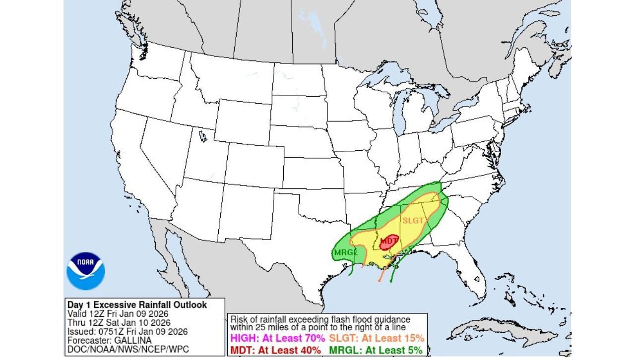
The latest Day 1 Excessive Rainfall Outlook shows the flood threat expanding westward into Texas, where repeated rounds of rain are expected to overspread areas already prone to rapid runoff.
What the Rainfall Outlook Clearly Shows
The NOAA/WPC outlook places:
- Eastern Texas and Louisiana within the Moderate Risk zone
- The risk extending east into Mississippi and Alabama
- A broader Slight to Marginal Risk reaching parts of Tennessee and Georgia
A Moderate Risk indicates a 40% or greater chance that rainfall will exceed local flash-flood guidance — a strong signal for numerous flooding issues, not just isolated spots.
Rainfall Totals and Rates
Forecast guidance supports:
- 2–4 inches of rain across much of the Moderate Risk area
- Localized 4–6 inch totals, especially from eastern Texas into Mississippi
- Rainfall rates of 2–3 inches per hour, capable of overwhelming drainage systems quickly
These amounts are especially concerning where storms train repeatedly over the same corridor, which models suggest is possible Friday into Friday night.
Why Flooding Risk Is Elevated
Several high-impact factors are aligning:
- Slow-moving storm clusters along a stalled frontal boundary
- Deep Gulf moisture fueling very efficient rainfall
- Back-to-back storm rounds, limiting recovery time
- Low-lying and urban areas across Texas and Mississippi highly vulnerable
Even areas outside the Moderate Risk zone could experience rapid flash flooding if heavy bands stall.
Areas of Highest Concern
- Eastern Texas: flash flooding possible in urban and rural areas due to intense short-term rainfall
- Mississippi: highest confidence for repeated heavy rain and runoff
- Alabama: western and central sections at risk as storms progress east
- Southern Tennessee: localized flooding possible later in the event
What Residents Should Watch For
- Flooded roadways and sudden water rises
- Low-water crossings becoming impassable
- Small creeks and streams rising quickly
- Travel disruptions during peak rainfall periods
Bottom Line
This setup does include Texas, and the data clearly supports a Moderate Risk of flash flooding from eastern Texas through Mississippi and into Alabama. With rainfall rates capable of overwhelming infrastructure in a short time, flooding is likely in the hardest-hit areas, not just possible.
Stay alert, avoid flooded roads, and monitor local warnings as conditions evolve. For continued regional weather updates and analysis, keep following ChicagoMusicGuide.com.