
Texas, Oklahoma, Arkansas, Tennessee, Kentucky, and the Carolinas Brace for Expanding Late-Week Winter Storm With Snow, Ice, and Arctic Air
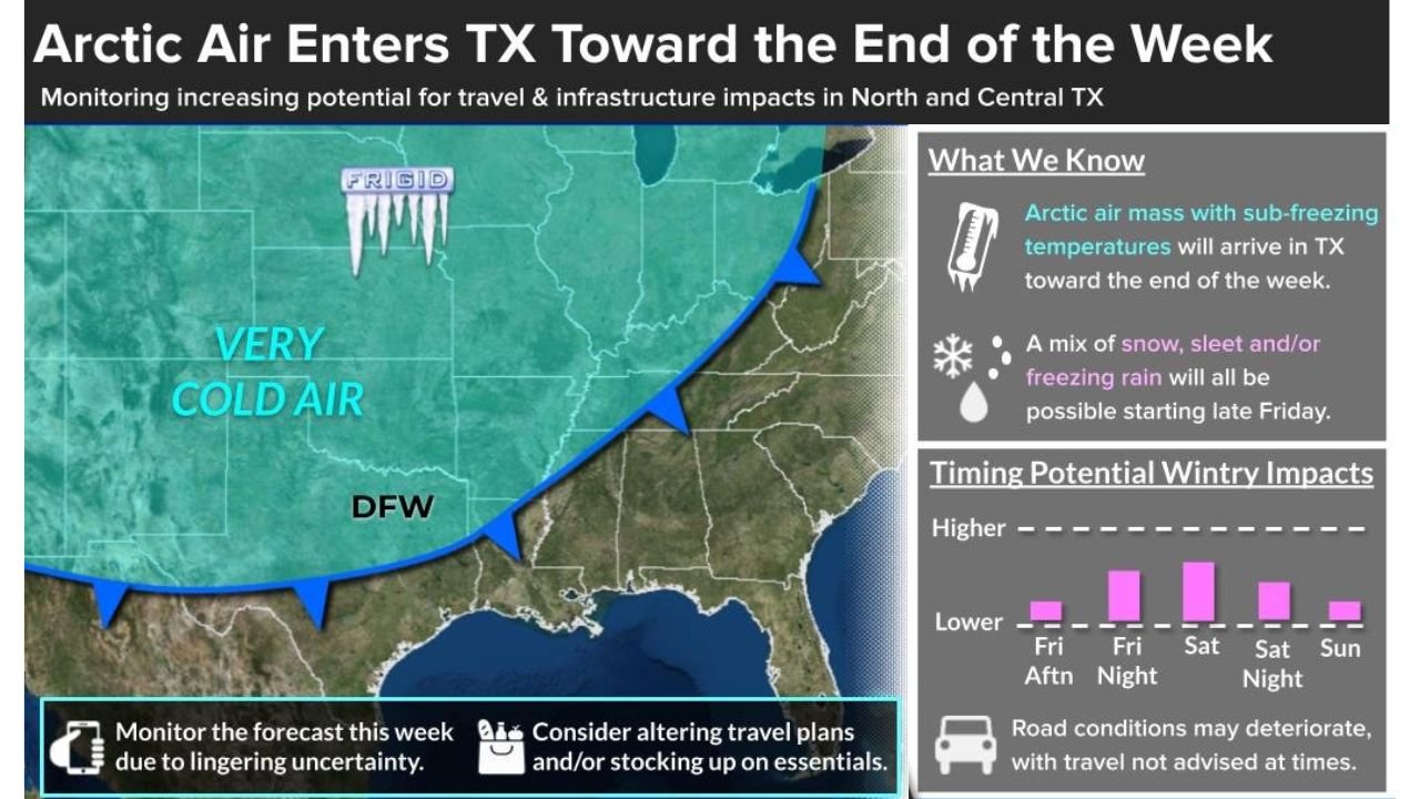
UNITED STATES — Confidence is increasing that a large late-week winter storm will organize across the central and eastern United States, bringing a combination of snow, ice, and Arctic cold from the Southern Plains through the Mid-South, Appalachians, and Mid-Atlantic between Friday and Sunday, January 24–26. Multiple model ensembles now show a broad swath of wintry precipitation, while Arctic air pushes south and east, setting the stage for potentially disruptive conditions across several states.
Strengthening Winter Storm Signal Across the Southern and Eastern U.S.
Forecast guidance continues to show a robust storm system developing over the Southern Plains, then sliding east-northeast through the Mississippi Valley and into the Eastern U.S. Model ensembles, including European and American guidance, have trended toward widespread precipitation coinciding with very cold surface air, a classic setup for winter weather well south of the typical snow belt.
The most consistent signal places Texas, Oklahoma, Arkansas, Missouri, Tennessee, Kentucky, West Virginia, Virginia, North Carolina, and South Carolina within the broader impact zone. While exact placement of the heaviest snow axis remains uncertain, confidence is growing that significant winter weather will affect a large geographic area, rather than a narrow corridor.
Snow Potential Expands, Including the Southern Plains and Mid-South
Snow probabilities have notably increased across parts of the Southern Plains, particularly Oklahoma, where recent ensemble runs show a meaningful chance of 4 inches or more, including metro areas. Farther east, a continuous band of accumulating snow is increasingly favored from Arkansas and Tennessee into Kentucky, West Virginia, and Virginia, with some guidance showing high probabilities for at least 3 inches across a wide swath.
This setup is unusual due to its size and southern reach, with snow chances extending into areas that typically see limited winter precipitation. While not everyone in the affected region will see heavy totals, the coverage of accumulating snow appears expansive, increasing the likelihood of travel disruptions.
Ice Threat Focused Across the Deep South and Carolinas
South of the primary snow band, ice accumulation is a growing concern, especially from North Texas and Arkansas into Mississippi, Alabama, Georgia, and the Carolinas. Forecast soundings suggest warm air aloft overrunning shallow Arctic air near the surface, a setup favorable for freezing rain and sleet.
Parts of North Georgia, South Carolina, and North Carolina currently stand out as areas with elevated risk for impactful icing, which could lead to hazardous road conditions, power outages, and tree damage. Even relatively small ice amounts can cause significant problems, particularly in regions unaccustomed to winter storms.
Timing, Duration, and What Could Still Change
The earliest impacts may begin as Friday across the Southern Plains, with wintry precipitation spreading east through Saturday and Sunday. Some guidance suggests the system could be slow-moving, increasing the risk of prolonged impacts in certain areas. However, exact timing, precipitation type, and totals remain uncertain, and even small shifts in storm track or temperature profiles could dramatically alter local outcomes.
A more northerly shift would expand snow farther north, while a southern track would enhance icing risks across the Deep South. Forecast confidence will improve over the coming days as the event moves into a shorter-range window.
As this late-January winter storm threat continues to evolve, residents across the Southern Plains, Mid-South, Appalachians, and Eastern Seaboard are urged to stay weather-aware, monitor official forecasts, and begin thinking about travel plans, cold-weather safety, and protecting people, pets, pipes, and plants.
For continued updates, regional breakdowns, and the latest winter weather coverage, keep following ChicagoMusicGuide.com as this developing storm takes shape.