
Upstate New York Buried by Historic Snowstorm as Syracuse Airport Records Nearly 20 Inches in a Single Day
NEW YORK — A powerful lake-effect snowstorm has delivered a historic snowfall to Central and Upstate New York, with Syracuse setting one of its most significant single-day snow totals in decades as intense snow bands continued to impact the region.
According to the latest climate summary, Syracuse Hancock International Airport recorded 19.3 inches of snow in just one day, making it the highest single-day snowfall at the airport since the legendary 1993 “Storm of the Century.” Snow was still falling at the time of the report, raising concerns that totals could climb even higher.
Syracuse Sets One-Day Snowfall Milestone
The climate data confirms that December 30, 2025, now stands out as a landmark winter weather day for Syracuse. The 19.3-inch total surpassed the previous daily benchmark of 18.6 inches set in 1997, firmly placing this event among the most extreme snowfalls in modern local records.
Despite the heavy snow, temperatures remained relatively stable for a winter storm of this magnitude. Syracuse recorded a high of 22°F, a low of 18°F, and an average temperature of 20°F, keeping snow light, powdery, and highly accumulative.
Snowfall Totals Surge Well Above Normal
The impact of this storm extends beyond a single day. Climate figures show 53.6 inches of snow month-to-date, far exceeding the normal December average of 29.5 inches. That places Syracuse more than 24 inches above normal snowfall for the month, an extraordinary deviation that highlights how dominant lake-effect systems have been this season.
Since July 1, snowfall has already reached 71.3 inches, nearly doubling what is typically expected by this point in the winter season. Snow depth currently stands at 15 inches, creating sustained wintry conditions across the region.
Lake-Effect Bands Target Central and Northern New York
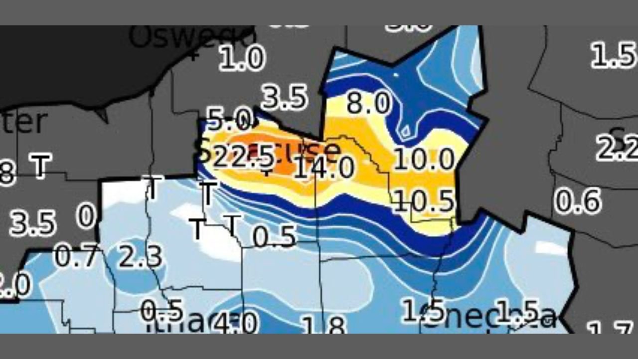
Snowfall mapping included in the data shows intense lake-effect bands extending east of Lake Ontario, with localized totals exceeding 20 inches in some areas. The sharp gradients visible on the map explain why snowfall amounts varied dramatically over short distances, a hallmark of lake-effect storms.
These bands focused energy directly into Central New York, keeping snow rates high for hours at a time and overwhelming standard snow removal efforts.
Why This Storm Stands Out
What makes this event especially notable is not just the snow total, but the rarity of such a high single-day accumulation in the modern climate record. The data indicates this is the largest daily snowfall at Syracuse Airport in more than three decades, reinforcing how exceptional the setup was.
With snow continuing during the observation window, forecasters cautioned that final totals may need to be updated as additional measurements are finalized.
What Comes Next
While the heaviest bands have begun shifting, lingering snow showers and cold conditions are expected to maintain winter hazards across Central New York. Roads, travel schedules, and outdoor events may continue to face disruptions as crews work to manage deep accumulations.
Snowstorms like this don’t just reshape landscapes — they reshape winter history. What do you think about this historic snowfall, and how is winter impacting your area? Share your thoughts and stay connected with the latest weather and regional updates at ChicagoMusicGuide.com.