
Valentine’s Day Night Tornado Risk Increasing Across East Texas and Southwest Louisiana as Models Signal Strengthening Setup
EAST TEXAS AND SOUTHWEST LOUISIANA — A growing nocturnal tornado risk is emerging for Valentine’s Day night (February 14) across parts of East Texas (ETX) and Southwest Louisiana (SWLA), as recent model runs trend toward a stronger severe weather setup. Meteorologists are closely watching the late-evening into overnight window, when ingredients may align for rotating thunderstorms capable of producing tornadoes.
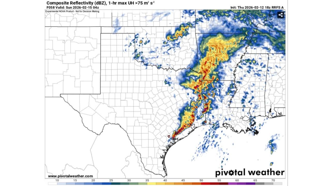
New high-resolution model guidance valid early February 15 highlights a corridor of enhanced storm activity stretching from southeast Texas through western and central Louisiana, with signals of strong wind shear and organized convection.
Model Trends Show Strengthening Severe Setup
Recent runs from the RRFS (Rapid Refresh Forecast System) indicate an increasingly favorable environment for severe storms late Friday night into early Saturday morning. Composite reflectivity projections show a line of intense thunderstorms pushing from coastal southeast Texas into western Louisiana.
Embedded within this line, model output highlights areas of enhanced updraft helicity — a signal often associated with rotating storms capable of producing tornadoes.
Sounding data from near 31.11°N, 92.97°W (central Louisiana) shows strong wind shear throughout the lower atmosphere, including favorable low-level helicity and steep wind profiles supportive of supercell structures.
Why Nocturnal Tornadoes Are Concerning
Nocturnal tornado setups carry additional risk because they occur while many residents are asleep. In this case, the most favorable window appears to be late evening February 14 through the early morning hours of February 15.
Key ingredients shown in model data include:
- Strong low-level wind shear
- Adequate instability
- A surging warm, moist air mass from the Gulf of Mexico
- An advancing upper-level disturbance enhancing lift
When these elements combine, rotating storms can develop quickly, especially along or just ahead of a squall line.
Highest Risk Zone: ETX into SWLA
Based on current model guidance, the primary corridor of concern includes:
- Tyler, Longview, and Nacogdoches, Texas
- Beaumont and Port Arthur, Texas
- Lake Charles, Louisiana
- Alexandria, Louisiana
- Areas along the I-10 corridor
Storms are projected to organize first across southeast Texas before tracking eastward into Louisiana during the overnight hours.
The alignment of strong shear vectors suggests storms may maintain structure as they cross state lines, keeping the tornado threat active into Louisiana after midnight.
Shear Profiles Support Organized Rotation
Wind profile data shows strong turning of winds with height, including supportive low-level directional shear. Critical angle values and storm-relative helicity parameters appear favorable for supercell development.
While instability values are not extreme, they are sufficient when combined with strong shear to produce organized severe storms. In nocturnal events, shear often becomes the dominant ingredient.
Forecasters stress that model guidance is still evolving, but the consistent signal of strengthening shear and organized convection over the past few runs has raised confidence that the threat deserves close monitoring.
What Residents Should Do
Residents across East Texas and Southwest Louisiana should:
- Review severe weather safety plans
- Ensure weather alerts are enabled on mobile devices
- Have multiple ways to receive warnings overnight
- Identify a safe shelter location in advance
Because the threat window occurs overnight, preparedness is especially important.
While not every severe setup produces tornadoes, the upward trend in model support indicates a need for heightened awareness.
As Valentine’s Day evening approaches, those with travel or event plans in East Texas and Louisiana should remain weather-aware. For continued updates on severe weather threats and regional impacts, visit ChicagoMusicGuide.com.