
Washington, D.C., Maryland, and Virginia Set for Warm, Rainy Christmas Week With Little Chance of Snow
WASHINGTON, D.C. — The Washington, D.C. metro region, including Maryland and Northern Virginia, is heading into Christmas week with unseasonably warm temperatures, continuing a mild pattern that stands in sharp contrast to earlier December conditions. Forecast data shows rain chances dominating the outlook, with little to no snowfall expected through Christmas Day and beyond.
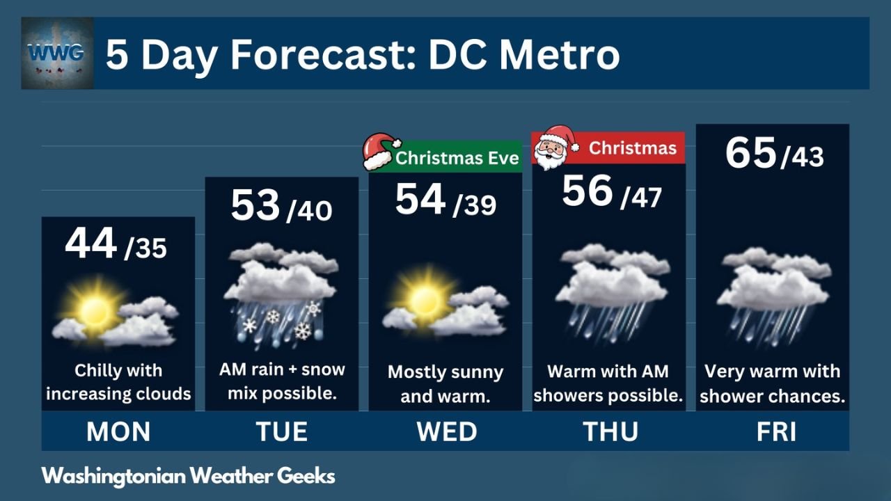
Meteorologists say the warm pattern will persist through the end of the workweek, with temperatures climbing well above average for late December and only a brief window for wintry weather early in the week.
Warm Christmas Week Takes Hold Across the DC Metro
Forecast highs across Washington, D.C., Maryland, and Virginia are expected to range from the mid-50s to mid-60s, values that are well above normal for late December. Christmas Day itself is projected to be especially mild, with highs near 56 degrees and a chance of light rain rather than snow.
By Friday, temperatures may climb even higher, approaching the mid-60s, reinforcing the overall theme of a warm and unsettled holiday period rather than a classic winter setup.
Brief Wintry Mix Possible Early Tuesday Morning
The only potential winter weather signal appears early Tuesday morning, when a passing cold front could briefly introduce a rain and snow mix, mainly during the morning hours. Forecasters emphasize that this window is short-lived, with temperatures rising quickly enough to transition precipitation to all rain shortly after onset.
Any snow accumulation appears unlikely, especially in urban and suburban areas, and impacts should remain minimal if the mix materializes at all.
Christmas Eve and Christmas Day Look Mild and Mostly Rain-Free
Christmas Eve is shaping up to be mostly sunny and warm, with highs near 54 degrees, providing favorable travel conditions across the region. Clouds may increase late, but significant precipitation is not expected during the daytime hours.
On Christmas Day, temperatures remain mild, though isolated rain showers are possible, particularly during the morning. Despite the presence of precipitation chances, the overall pattern strongly favors rain instead of snow, disappointing those hoping for a white Christmas in the Mid-Atlantic.
Rain Chances Linger Into Late Week
Forecast guidance shows shower chances continuing into Friday, paired with very warm temperatures for the season. This extended mild pattern reflects persistent southerly flow and a lack of sustained cold air across the eastern United States.
Soils may become increasingly damp, but no significant flooding or winter storm threats are indicated at this time for Washington, D.C., Maryland, or Virginia.
Why This Pattern Matters for the Region
The warm Christmas week highlights a broader trend of temperature volatility across the Mid-Atlantic this winter. While brief cold snaps remain possible later in the season, the current setup favors rain events over snow, especially near major population centers.
Residents planning holiday travel, outdoor gatherings, or events can expect generally favorable conditions, though umbrellas may still be needed at times.
As Washington, D.C., Maryland, and Virginia move through Christmas week under this mild pattern, staying informed remains important as forecast details continue to evolve. For continued weather updates, holiday forecasts, and regional coverage, visit ChicagoMusicGuide.com.