
Washington DC Richmond And Baltimore Face Growing Drought Risk As Rainfall Stalls And Dry Pattern Expands Across Mid Atlantic
WASHINGTON, D.C. — A concerning dry weather pattern is tightening its grip across the Mid-Atlantic, with cities like Washington D.C., Richmond, and Baltimore experiencing below-average rainfall and worsening drought conditions following an already dry March.
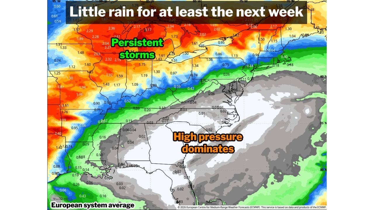
Dry Spring Pattern Emerging Across Mid Atlantic Region
Spring is typically known for bringing frequent rain and unsettled weather to the region, but this year is shaping up very differently. April is already trending below average for precipitation, continuing a dry trend that began in March.
Across the Mid-Atlantic corridor, including Washington D.C., Baltimore, and northern Virginia, rainfall has been limited, and forecasts suggest very little relief in the near future.
This shift away from typical spring rainfall patterns is being driven by a dominant high-pressure system, which is suppressing storm activity and keeping skies largely clear.
Drought Conditions Intensifying Around Richmond And Virginia
Recent updates indicate that drought conditions are beginning to worsen, particularly across parts of Virginia, where areas near Richmond have now slipped into severe drought status.
Meanwhile:
- Washington D.C. and surrounding suburbs remain in moderate drought
- Broader parts of the Mid-Atlantic region continue to show dry soil conditions
- The lack of rainfall is gradually expanding the footprint of drought zones
This marks a noticeable shift compared to previous weeks, signaling that dry conditions are not only persisting but intensifying.
Little Rain Expected Over The Next Week And Beyond
Forecast models show that the region is likely to see minimal rainfall over the next 7 to 10 days, with only light precipitation totals possible—generally a tenth to two-tenths of an inch at most.
In Washington D.C., the current dry stretch has already reached five consecutive days without measurable rain, and the outlook suggests more of the same through the coming week.
Beyond that timeframe, forecast confidence decreases slightly, but overall trends still favor a continued dry pattern extending deeper into the month.
High Pressure System Blocking Storm Activity
The primary driver behind this prolonged dry spell is a strong high-pressure system dominating the southeastern United States.
This system is effectively:
- Blocking moisture from reaching the Mid-Atlantic
- Redirecting storm systems northward into the Great Lakes region
- Maintaining stable, dry air across Washington D.C., Virginia, and Maryland
As long as this pattern remains in place, opportunities for meaningful rainfall will remain limited.
What Residents Should Expect Moving Forward
Residents in Washington D.C., Richmond, Baltimore, and surrounding areas should prepare for:
- Continued dry conditions with limited rainfall chances
- Increasing drought severity in some locations
- Potential impacts on gardening, agriculture, and water usage
- Ongoing stretches of sunny, stable weather with minimal storm activity
With no major pattern shift expected in the immediate future, this dry trend could become one of the defining weather patterns of the early spring season across the Mid-Atlantic.
For more updates on regional weather patterns, drought conditions, and seasonal outlooks, visit ChicagoMusicGuide.com for the latest coverage and detailed reports.