
Western New York Faces Icy Wednesday Morning as Slight Temperature Shift Raises Risk of Freezing Rain and Wintry Mix
BUFFALO, NEW YORK — A developing midweek storm system could bring icy travel conditions to Western New York on Wednesday, as new high-resolution guidance shows a subtle but important shift toward slightly colder surface temperatures. That small temperature adjustment may be enough to tip portions of the region from cold rain into a wintry mix or freezing rain scenario, particularly during the morning and early afternoon hours.
Forecast data valid for Wednesday afternoon indicates a narrow but impactful zone where precipitation type could fluctuate between rain, sleet, and freezing rain, depending on surface temperatures that are hovering within just a degree of freezing.
A One-Degree Difference Could Change Everything
Meteorologists analyzing the latest NAM 3km guidance note that Western New York is sitting on a razor-thin temperature margin. Surface readings across parts of Buffalo, Niagara County, Rochester, and surrounding communities are forecast to remain close to 32°F, creating a delicate balance between liquid rain and ice accretion.
Over the past 24 hours, models have trended slightly colder at the surface, increasing the probability that precipitation may freeze on contact in some areas. This subtle cooling trend raises concern for:
- Freezing rain accumulation
- Slick untreated roads
- Hazardous morning commutes
- Rapid changes in precipitation type
Forecasters caution that this is a low-confidence and highly complicated forecast, with precipitation types potentially changing back and forth during the day.
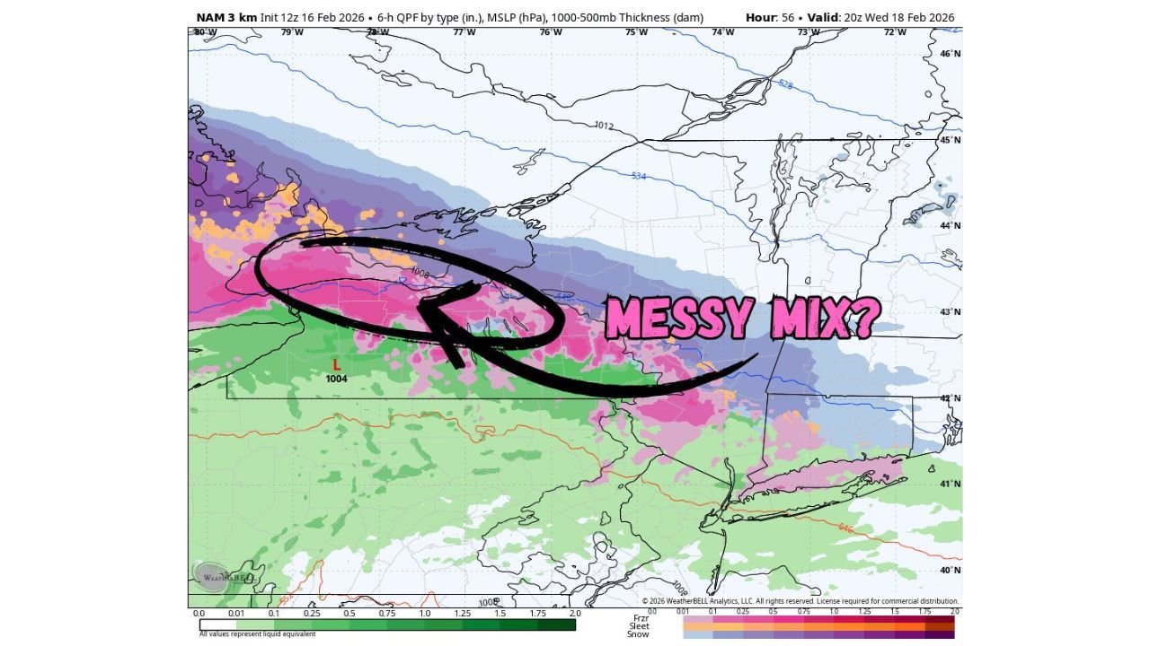
Messy Mix Possible Across Western New York
Precipitation maps show a band of mixed precipitation extending from south of Lake Ontario through Buffalo and into interior Western New York, with snow north of the band and primarily rain farther south.
The most likely scenario includes:
- Snow or a wintry mix north of Buffalo and toward Lake Ontario
- Freezing rain or sleet across portions of Buffalo and nearby suburbs
- Rain more dominant farther south, depending on surface temperatures
Because Western New York lies near the transition zone, even minor shifts in the storm track or thermal profile could alter impacts significantly.
Timing: Wednesday Morning Through Afternoon
The highest risk window for icy conditions appears to begin Wednesday morning, potentially impacting early travel. Conditions may continue fluctuating through the afternoon as surface temperatures respond to daytime influences.
Forecasters emphasize that the degree of impact — including exact precipitation types and amounts — will become clearer as additional high-resolution data becomes available.
At this stage, messaging focuses on the possibility of icy travel, rather than confirmed widespread ice accumulation. Still, even light freezing rain can create dangerous conditions on bridges, overpasses, and untreated surfaces.
Forecast Confidence Remains Low but Trends Are Notable
While confidence remains limited, the recent trend toward colder surface air cannot be ignored. Western New York is essentially one degree away from a more impactful icing event, making this a forecast that requires close monitoring.
Residents in Buffalo, Niagara Falls, Rochester, and surrounding communities should prepare for potential slick conditions and stay updated as Wednesday approaches.
As this midweek system evolves, ChicagoMusicGuide.com will continue monitoring precipitation trends and travel impacts across Western New York and the broader Northeast. For ongoing updates on winter weather developments and regional forecasts, visit ChicagoMusicGuide.com.