New York, Vermont, and Massachusetts Face New Year Snow Squalls With Travel Disruptions Across Adirondacks, Greens, and Berkshires
New York, Vermont, and Massachusetts are entering 2026 under a renewed winter pattern, as widespread light snowfall transitions into dangerous snow squalls overnight into New Year’s morning, according to the latest forecast data. Multiple weather maps and advisories show lake-enhanced snowfall, fast-moving squall lines, and localized heavier bands producing rapid accumulations and major travel impacts, especially across upstate New York and western New England.
Forecast guidance indicates 1–3 inches of snow for most areas, but higher totals of 3–5 inches are expected in the southwestern Adirondacks, southern Green Mountains, and northern Berkshires, where snowfall rates may briefly spike to near whiteout conditions during squalls.
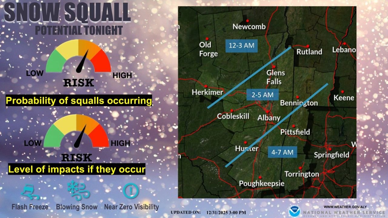
Snow Squalls to Intensify Overnight Across New York, Vermont, and Massachusetts
The most significant threat comes from snow squalls developing after midnight, driven by a sharp cold front crossing the Northeast. Forecast timing shows the squall line moving from central and eastern New York between 12 a.m. and 3 a.m., reaching western Massachusetts and southern Vermont between 3 a.m. and 7 a.m.
While these squalls may only last 15 to 30 minutes, they can produce intense snowfall rates, sudden flash freezing, and near-zero visibility, especially along higher terrain corridors. This setup is particularly concerning for overnight and early-morning travel on Interstate 90, Interstate 87, Route 7, and secondary mountain roads.
Northern areas are expected to see slightly higher totals due to pre-squall snow showers, which allow accumulation to build before the main burst arrives.
Adirondacks, Green Mountains, and Berkshires See Highest Snowfall Totals
Snowfall projections show a clear gradient, with higher elevations receiving the most accumulation. The southwestern Adirondacks of New York, including areas near Old Forge and Herkimer County, are forecast to see 3–5 inches, supported by lake-enhanced moisture.
In Vermont, snowfall increases across the southern and central Green Mountains, with 2–4 inches common and locally higher amounts where terrain enhances snowfall intensity. Rutland County and surrounding highlands sit squarely within the heavier zone.
Meanwhile, western Massachusetts, particularly the northern Berkshires around Pittsfield, is expected to pick up 2–4 inches, with brief periods of heavier snow during the squall passage. Lower elevations and valleys will generally remain closer to 1–2 inches, but rapid accumulation remains possible.
Winter Weather Warnings and Travel Risks Expand Regionwide
Weather alerts show a mix of Winter Storm Warnings, Winter Weather Advisories, and Lake-Effect Snow Warnings across upstate New York, with advisories extending into Vermont and Massachusetts. These alerts highlight the combination of snowfall, gusty winds, and sharply falling temperatures that could lead to slick and untreated roadways.
Snow squalls pose a unique risk because conditions can deteriorate within minutes, leaving drivers little time to react. Forecast data emphasizes the potential for blowing snow, flash freeze events, and chain-reaction accidents during peak squall timing.
Residents and travelers are urged to monitor real-time local forecasts, particularly if driving during the overnight or early New Year’s morning hours.
Seasonal Snowfall Trends Show Sharp Regional Divide
Seasonal snowfall percentile maps provide important context for this event. Much of the western United States remains far below average for snowfall, while the Great Lakes and Northeast—including New York, Vermont, and Massachusetts—are running well above normal for early winter.
Large portions of the Northeast are currently in the 90th to 99th percentile for seasonal snowfall, meaning these regions have already received more snow than most years dating back to 2008. This ongoing pattern supports continued winter activity heading deeper into January.
As New York, Vermont, and Massachusetts continue to navigate an active start to 2026, residents should remain cautious during snow squalls and rapidly changing conditions. For continued weather updates, winter alerts, and regional coverage, stay connected with ChicagoMusicGuide.com for timely information as the season unfolds.