Colorado Atmospheric River Could Deliver Biggest Mountain Snowfall of the Season Next Week While Denver Misses Out
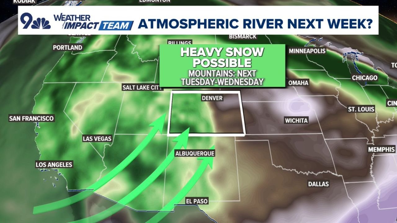
DENVER, COLORADO — A developing atmospheric river pattern could bring what forecasters say may be the largest mountain snow event of the season to parts of Colorado next Tuesday and Wednesday. While high elevations west of Denver could see heavy accumulation, early projections suggest the city of Denver itself may see little to no impact.
Forecast models highlighted by the 9NEWS Weather Impact Team show a strong plume of Pacific moisture streaming inland from Southern California and pushing through Nevada, Utah, and into the Colorado Rockies. The setup is focused primarily on the state’s mountain regions, with snow chances increasing significantly in higher elevations.
Heavy Snow Potential Focused on Colorado Mountains
Meteorologists are monitoring a pronounced moisture surge aimed directly at the central and northern Colorado mountains. The atmospheric river pattern typically delivers prolonged precipitation, and in winter conditions, that often translates to significant snow at higher elevations.
The projected timeframe for the strongest impacts is Tuesday into Wednesday next week, when deep moisture and colder air combine across mountain terrain. Forecasters note that this system could produce the biggest snow totals since early December — and potentially the largest event of the season so far — if current trends hold.
Communities near Vail, Breckenridge, Steamboat Springs, and along the I-70 mountain corridor could benefit from fresh snow, a welcome development for ski resorts and winter recreation. Resorts across Colorado have experienced inconsistent snowfall this season, making a strong midweek event especially meaningful for tourism and snowpack.
Denver Likely to Miss the Main Impact
Despite the impressive mountain setup, projections currently show Denver sitting outside the core moisture zone. Model graphics indicate that while areas west of the Front Range see widespread green shading (representing heavy precipitation), eastern plains and the metro corridor remain largely dry.
This pattern has become somewhat familiar this winter, with several systems favoring the mountains while bypassing lower elevations. The moisture plume appears to track west of the Front Range, limiting snow potential for Denver and surrounding suburban communities.
If this trend holds, the city may see little measurable precipitation, even as higher elevations receive substantial totals. That contrast could once again highlight Colorado’s dramatic microclimates — where a short drive into the mountains brings entirely different weather conditions.
Atmospheric River Pattern Explained
An atmospheric river refers to a long, narrow corridor of concentrated water vapor transported from the Pacific Ocean. When these systems move inland and encounter mountain terrain, the air rises and cools, producing heavy precipitation — often intense snowfall during colder months.
In this case, the moisture stream appears to originate near Southern California, sweeping northeast across Las Vegas, through Salt Lake City, and into Colorado. The trajectory favors upslope enhancement in mountainous regions, increasing the likelihood of prolonged snow in high elevations.
While confidence remains moderate at this stage, meteorologists emphasize that details such as exact snowfall totals, snow levels, and storm intensity will become clearer in the coming days. Mountain communities should monitor updates as the event approaches.
What This Means for Travel and Ski Season
If snowfall projections verify, travel through mountain passes such as Vail Pass, Eisenhower Tunnel, and Loveland Pass could become hazardous Tuesday and Wednesday. Drivers should be prepared for chain restrictions, reduced visibility, and snow-packed roads.
For ski areas, however, the system could provide a midseason boost. Fresh snow accumulation improves conditions, enhances base depth, and supports extended winter operations. Resorts and tourism operators will be watching closely.
As always with Colorado weather, slight shifts in the storm track could change impacts for both mountains and lower elevations. Denver residents hoping for measurable snowfall will be watching for any eastward adjustment in the moisture plume.
As Colorado prepares for what could be its most significant mountain snow event in weeks, weather watchers across the state will be monitoring updates closely. For continued coverage on weather developments, live event updates, and regional news affecting music festivals and winter events, visit ChicagoMusicGuide.com.