Storm Prediction Center Unveils New Day 1 Outlook Graphics as Marginal Severe Risk Stretches from Texas and Oklahoma to Illinois and Indiana
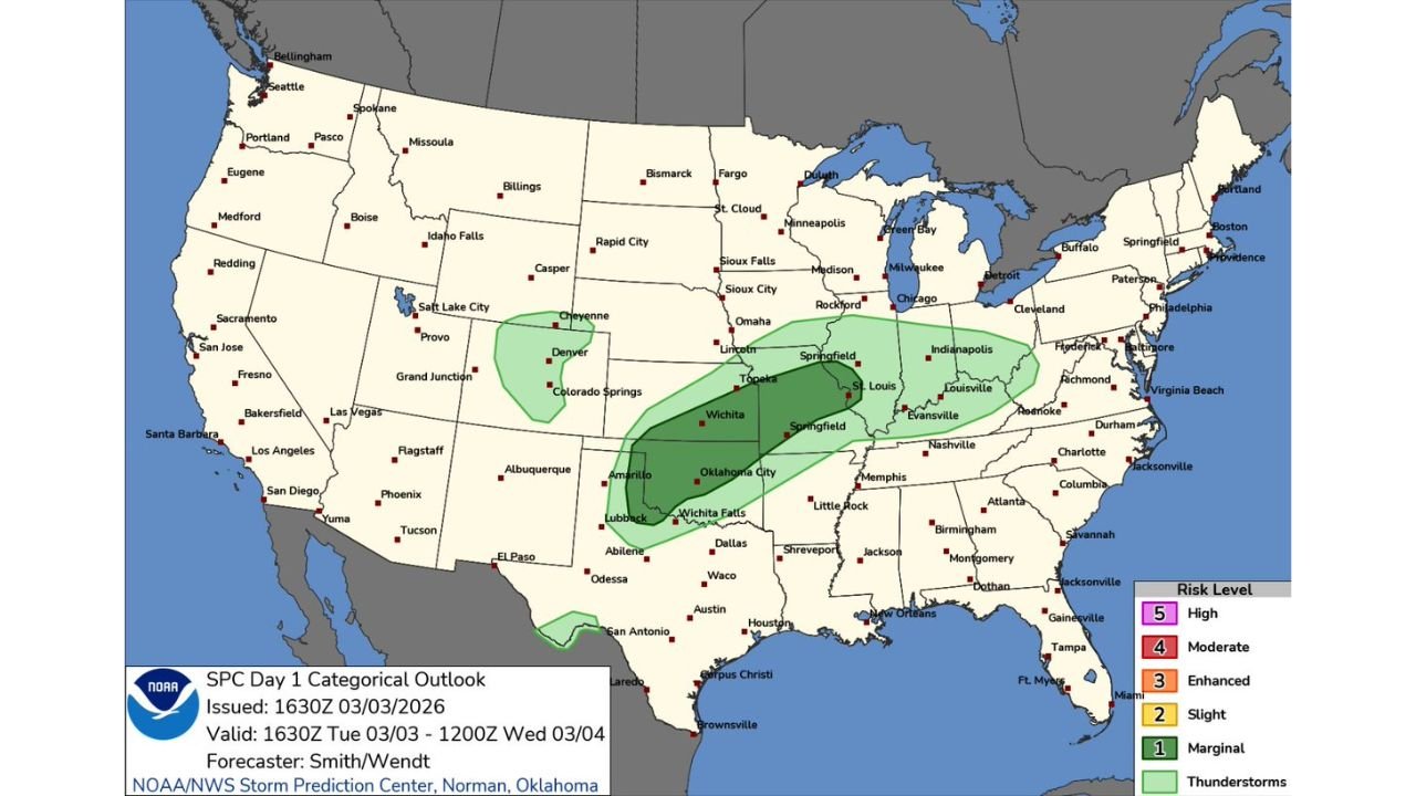
UNITED STATES — The Storm Prediction Center (SPC) has officially rolled out its updated Day 1 categorical outlook graphics, and the first map under the new design highlights a broad but lower-end severe weather risk stretching from the southern Plains into the Midwest.
While no higher-end risk categories are in play, the refreshed look marks a visual shift for one of the nation’s most closely watched severe weather products.
New SPC Graphics Debut
According to the latest Day 1 outlook issued at 1630Z on March 3, 2026, the updated maps feature cleaner shading and simplified visuals, though the categorical levels themselves remain unchanged for now.
The risk scale still includes:
- Marginal (Level 1)
- Slight (Level 2)
- Enhanced (Level 3)
- Moderate (Level 4)
- High (Level 5)
No new CIG (Conditional Instability Gradient) hatching appears in this initial release, but forecasters indicate additional refinements may be added in coming days.
Where Storms Are Expected Today
The current Day 1 outlook highlights a Marginal Risk (Level 1 of 5) across a long corridor that includes parts of:
- Texas (including Amarillo, Lubbock, and near Wichita Falls)
- Oklahoma (Oklahoma City area)
- Kansas (Wichita and Topeka)
- Missouri (Springfield and St. Louis)
- Illinois (including Springfield and areas southwest of Chicago)
- Indiana (Indianapolis and Louisville region)
- Portions of western Kentucky
Cities such as Oklahoma City, Wichita, Springfield (MO), St. Louis, Indianapolis, and Louisville fall within the green-shaded marginal zone.
Secondary Risk in Colorado
A separate Marginal Risk area is also highlighted over eastern Colorado, including:
- Denver
- Colorado Springs
- Areas near Cheyenne, Wyoming
This suggests isolated thunderstorm potential along the Front Range, though widespread severe weather is not expected.
What a Marginal Risk Means
A Level 1 Marginal Risk indicates:
- Isolated strong to locally severe thunderstorms possible
- Limited coverage of severe reports
- Brief damaging wind gusts or small hail as primary threats
The elongated shape of the risk zone suggests a frontal boundary or moisture gradient extending northeast from the southern Plains into the Midwest.
Midwest Focus: Illinois and Indiana in the Zone
For readers in the Chicago region and surrounding Midwest communities, the southern half of Illinois and much of Indiana sit inside the outlook area.
While Chicago itself is near the northern edge of the risk zone, areas closer to Springfield, St. Louis, and Indianapolis appear more centered within the highlighted corridor.
This setup typically favors:
- Scattered afternoon and evening thunderstorms
- Isolated gusty winds
- Brief heavy downpours
Widespread tornado or significant severe outbreaks are not indicated at this time.
Southern Plains Setup
In Texas and Oklahoma, the risk stretches from Amarillo and Lubbock northeast through Oklahoma City and into southern Kansas.
These regions often see early-season thunderstorm development along drylines or weak frontal boundaries. However, the absence of a Slight Risk upgrade suggests limited instability or weaker wind shear compared to classic Plains severe setups.
Why the Graphic Update Matters
The SPC’s outlook graphics are widely used by:
- Emergency managers
- Broadcast meteorologists
- Storm chasers
- National media outlets
The updated design aims to improve clarity and readability, especially for mobile and digital platforms.
Though today’s map does not showcase higher-end categories, future events may incorporate expanded visual features such as CIG hatching to highlight conditional severe threats.
Bottom Line
The new SPC Day 1 outlook graphics debut alongside a broad Marginal Risk spanning Texas, Oklahoma, Kansas, Missouri, Illinois, and Indiana, with a secondary zone over eastern Colorado.
Severe weather potential today appears isolated and limited, but the visual refresh marks a new chapter in how national severe weather risks are presented.
ChicagoMusicGuide.com will continue tracking both evolving storm threats and changes in national weather products as the spring severe season ramps up.