Bi-Modal Severe Storm Setup Could Trigger Tornadoes and Damaging Winds Across Kansas, Missouri, Iowa, Oklahoma, Arkansas and Illinois Friday
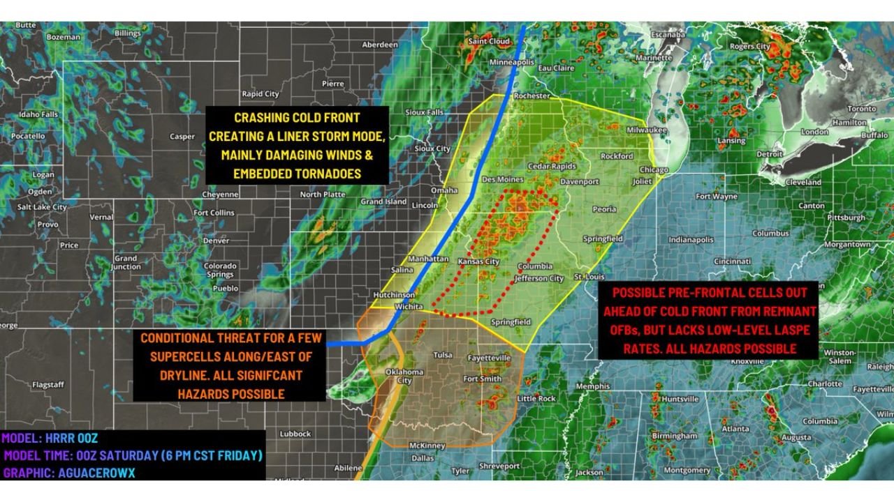
KANSAS CITY, MISSOURI — A potentially dangerous bi-modal severe weather setup is developing across the Southern and Central Plains into the Mid-Mississippi River Valley, where meteorologists say a fast-moving crashing cold front could trigger a widespread outbreak of damaging winds, embedded tornadoes, and isolated supercells on Friday.
Weather model guidance shows storms forming from Kansas and Oklahoma through Missouri and Iowa, then spreading toward Illinois and parts of the Midwest as the powerful cold front races east. The event could unfold in two separate storm modes, meaning multiple storm types may develop in different regions at the same time.
Meteorologists say the final outcome will depend heavily on daytime heating, atmospheric instability, and storm development timing, all factors that could determine whether storms remain scattered or intensify into a more significant severe weather outbreak.
Northern Storm Mode: Crashing Cold Front Could Produce Damaging Wind Line
The northern storm mode is expected to develop along the fast-moving cold front pushing through the central Plains into the Upper Midwest. Forecast models show storms rapidly organizing into a line of severe thunderstorms, a setup often associated with widespread damaging winds and embedded tornadoes.
Areas from central Kansas through Missouri, Iowa, and potentially into Illinois may experience the strongest effects from this system.
Forecasters warn that this type of storm structure—often called a linear storm mode or squall line—can produce:
- Damaging straight-line winds exceeding 60–70 mph
- Brief embedded tornadoes within the storm line
- Heavy rain and lightning
In addition to the primary line of storms, there is also concern about pre-frontal storm development in the open warm sector ahead of the cold front. If isolated storms form in this zone, they could become stronger and more organized.
However, meteorologists caution that poor low-level lapse rates—a measurement related to how quickly air cools with height—may limit storm intensity early in the day. If surface heating increases later in the afternoon, these storms could rapidly strengthen.
Southern Storm Mode: Supercells Possible Along the Dryline
At the same time, a second storm mode may develop farther south across Oklahoma, northern Texas, and parts of Arkansas, where a dryline boundary could spark isolated but potentially dangerous thunderstorms.
This southern setup carries what meteorologists describe as a conditional threat for supercells, meaning only a few storms may develop—but any that do could become intense quickly.
Supercells are capable of producing all significant severe hazards, including:
- Large hail
- Damaging winds
- Strong tornadoes
Forecast models indicate these storms could develop along or just east of the dryline, particularly across western Oklahoma into southern Kansas. If the environment becomes unstable enough, storms could rapidly intensify.
Still, there is uncertainty. Experts say lack of strong atmospheric forcing during the daytime hours may delay storm formation.
Timing Could Push Storm Development Into the Evening
One key factor that could change the severity of the event is timing.
Some models suggest storms may wait until after sunset to fully develop as the cold front pushes into the unstable air mass across the Plains and Mid-Mississippi Valley.
If that occurs, storms could become more organized and widespread during the evening and nighttime hours, potentially impacting communities across:
- Kansas
- Missouri
- Iowa
- Oklahoma
- Arkansas
- Illinois
Nighttime severe weather events are often considered more dangerous because storms can intensify rapidly while visibility decreases and people may be asleep.
Areas From Kansas City to Chicago Could See Severe Weather Impacts
The forecast corridor currently highlights a large region stretching from Wichita and Kansas City through Des Moines and toward Chicago as being within the broader risk zone.
Cities that could see severe weather threats include:
- Wichita, Kansas
- Kansas City, Missouri
- Columbia and Jefferson City, Missouri
- Des Moines, Iowa
- Springfield, Missouri
- Tulsa, Oklahoma
- Chicago, Illinois
While not every city will experience severe storms, forecasters say the overall environment across the Plains and Midwestern states is capable of supporting multiple severe weather hazards if storms fully develop.
Meteorologists Monitoring Instability and Heating Levels
The biggest uncertainty heading into Friday remains how unstable the atmosphere becomes during the afternoon.
If cloud cover limits warming, storms may struggle to intensify early in the day. But if temperatures rise enough to increase atmospheric energy, storms could mature quickly and become severe across multiple states.
Meteorologists are closely watching surface heating trends, moisture levels, and storm initiation timing, which will determine how widespread the severe weather threat becomes.
This evolving setup highlights how dynamic spring weather patterns across the Plains and Midwest can produce multiple storm types within the same system.
As weather conditions continue to evolve, forecasters will refine risk areas and provide updated severe weather outlooks for the region.
As communities across the Central Plains and Mid-Mississippi Valley prepare for the approaching storm system, residents are encouraged to stay weather-aware and monitor local forecasts. For more updates on major weather events, storms, and regional forecasts, visit ChicagoMusicGuide.com for continuing coverage.