Strong Storm Line Could Sweep Across Chicago and Northern Illinois Friday Night With Damaging Winds, Hail, and Possible Tornadoes
CHICAGO, ILLINOIS — Forecasters say multiple rounds of strong to severe thunderstorms could move across northern Illinois Friday into early Saturday morning, with the greatest threat arriving Friday night when a powerful squall line develops along a cold front moving in from the central Plains.
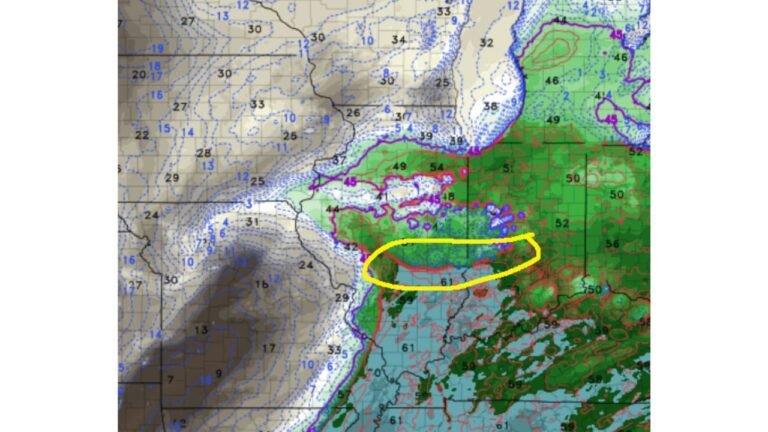
Weather models indicate an initial round of storms late Friday morning and early afternoon, followed by a more significant round later in the evening that could bring damaging winds, hail, and isolated tornadoes across the Chicago region and much of northern and central Illinois.
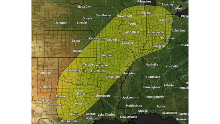
Meteorologists say the system is part of a larger severe weather outbreak expected to develop across the Plains and Mid-Mississippi Valley before advancing east into Illinois.
First Round of Storms Possible Friday Late Morning
The first wave of thunderstorms is expected to move across northern Illinois during the late morning and afternoon hours on Friday.
This initial round is currently expected to bring a relatively low-end severe weather threat, mainly including:
- Localized gusty winds
- Small to marginally severe hail
Forecasters say this early activity is not expected to produce widespread severe weather, but it could still bring brief downpours and thunder across areas including:
- Chicago
- Rockford
- Aurora
- DeKalb
- Joliet
- Kankakee
After this first round passes, the atmosphere is expected to clear somewhat and warm into the 60s during the afternoon, allowing the air mass to become increasingly unstable.
Destabilizing Atmosphere Sets Stage for Evening Storm Development
By Friday afternoon, meteorologists expect destabilization across Illinois as warmer air and moisture build ahead of an approaching cold front.
At the same time, new storms are forecast to develop across the central Plains, including areas of Kansas, Missouri, and Oklahoma, where severe weather could begin earlier in the day.
Those storms are expected to organize into a squall line and move east toward Illinois during the evening and overnight hours.
This line of storms may strengthen as it travels into the Mid-Mississippi Valley, eventually reaching northern and central Illinois late Friday night.
Squall Line Could Arrive Across Northern Illinois Between 9 PM and 4 AM
Forecast guidance suggests the main line of storms may move through northern Illinois between roughly 9 PM Friday and 4 AM Saturday.
During this period, the strongest storms could produce:
- Scattered damaging wind gusts
- Hail
- Embedded QLCS tornadoes
QLCS tornadoes occur within fast-moving lines of thunderstorms and can develop quickly, sometimes with little warning.
Cities that could see the strongest impacts include:
- Chicago
- Aurora
- Rockford
- Peoria
- Bloomington
- Springfield
- Galesburg
- Moline
Meteorologists say the storm line may still be strong as it pushes east across Illinois overnight, producing pockets of severe weather along the way.
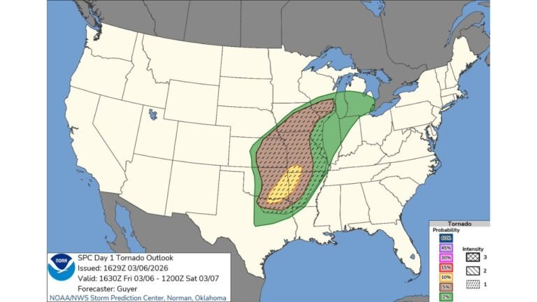
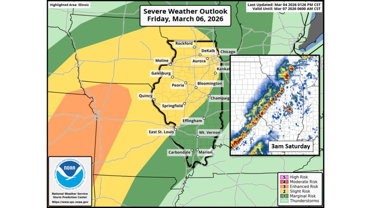
NOAA Outlook Highlights Large Portion of Illinois for Severe Storm Risk
The Storm Prediction Center’s severe weather outlook for Friday, March 6, 2026, shows much of central and northern Illinois under a Slight Risk for severe weather, indicating the possibility of scattered severe storms.
Areas across western Illinois closer to the Mississippi River, including Quincy and parts of western Illinois, are closer to the Enhanced Risk region, where severe storms may become more numerous.
Meanwhile, southern parts of the state remain under a Marginal Risk, where isolated storms are still possible.
Forecasters emphasize that even within lower risk areas, individual storms could still produce damaging weather.
Overnight Storms Often Pose Higher Safety Risks
Because the strongest storms may arrive overnight, meteorologists warn residents to remain prepared for potential severe weather alerts while sleeping.
Nighttime storms are often considered more dangerous because people may not immediately receive warnings, especially if they rely on outdoor sirens.
Experts recommend ensuring that weather alerts are enabled on smartphones or weather radios, particularly across Chicago and the surrounding northern Illinois communities.
Forecast Updates Expected As New Data Arrives
Forecasters say the storm outlook could still change as new data becomes available.
Meteorologists will continue monitoring high-resolution forecast models, atmospheric instability levels, and the timing of the approaching cold front to determine how intense the storm line may become as it reaches Illinois.
Additional forecast updates are expected as the system approaches.
As severe weather season begins to ramp up across the Midwest, residents across Chicago, Rockford, Aurora, and other northern Illinois communities are encouraged to stay aware of changing weather conditions.
For the latest updates on severe weather threats, Midwest storm systems, and regional forecast coverage, visit ChicagoMusicGuide.com.