After-Dark Supercell Threat Emerging Along Texas–Oklahoma Border as Storm Models Signal Rotating Storms Near Altus, Vernon, and Lawton
ALTUS, OKLAHOMA — Weather models are increasingly pointing toward potential supercell thunderstorm development along the Texas–Oklahoma border after dark, raising concerns for large hail, damaging winds, and possible tornadoes across parts of southwestern Oklahoma and northern Texas.
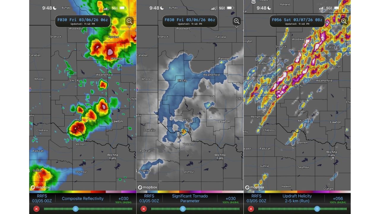
Forecast guidance from the RRFS 00z model run indicates that additional supercells could form late Friday evening, particularly near communities including Altus, Lawton, Vernon, Elk City, Weatherford, and surrounding areas.
While some models show slightly less aggressive storm development, meteorologists say the overall environment suggests a growing risk for severe weather across the region, making Friday a day when residents should remain weather-aware throughout the evening and overnight hours.
Forecast Models Signal Rotating Storm Development
The RRFS model guidance suggests several clusters of thunderstorms could organize into rotating supercells along the Texas–Oklahoma border, particularly in areas southwest of Altus and near Vernon, Texas.
Radar simulations show storms strengthening as they move northeast toward Lawton and Elk City, where atmospheric conditions appear capable of supporting strong updrafts and organized storm rotation.
These types of storms are capable of producing multiple severe hazards, including:
- Large hail
- Damaging wind gusts
- Isolated tornadoes
Meteorologists note that storms forming within this corridor could intensify quickly if they remain isolated rather than merging into a larger storm complex.
Atmospheric Conditions Favor Severe Storm Potential
Forecast soundings across the region indicate a volatile atmospheric setup, with key ingredients aligning to support strong thunderstorms.
Meteorological analysis shows:
- Surface dew points near the mid to upper 60s
- Strong wind shear throughout the atmosphere
- Moderate instability capable of fueling thunderstorm growth
These conditions allow storms to develop strong rotating updrafts, increasing the chances of supercell development capable of producing hail and tornadoes.
Model analysis also shows significant updraft helicity signals, which meteorologists use to identify areas where rotating storms may form within model simulations.
Storm Development May Shift Further North
While the RRFS model focuses storm development along the Texas–Oklahoma border, other forecast models such as the HRRR indicate storms may form slightly farther north across western and central Oklahoma.
This uncertainty means several communities across the region could experience severe weather impacts, including:
- Altus, Oklahoma
- Lawton, Oklahoma
- Elk City, Oklahoma
- Weatherford, Oklahoma
- Vernon, Texas
- Wichita Falls, Texas
Meteorologists say the exact storm track will depend on where instability and atmospheric forcing become strongest during the evening hours.
Squall Line Could Form Later in the Night
As storms continue to develop, forecasters say individual supercells may eventually merge into a larger line of storms, particularly overnight.
When storms organize into a squall line, the primary hazard often shifts from isolated tornadoes to widespread damaging wind gusts capable of causing structural damage and power outages.
However, even within a line of storms, embedded tornadoes can still occur, especially in environments with strong wind shear.
Residents Urged to Remain Weather Aware
Meteorologists stress that while forecast models still show some differences in storm placement, the overall setup suggests a heightened severe weather risk across the Texas–Oklahoma border region Friday evening.
Because storms may develop after sunset, forecasters recommend that residents ensure they have multiple ways to receive severe weather alerts, especially overnight.
Weather experts say nighttime severe storms can be particularly dangerous because warnings may occur while many people are asleep.
Residents across southwestern Oklahoma and northern Texas are encouraged to monitor local weather updates and stay prepared for potential severe storm warnings.
For the latest updates on severe storm forecasts, Midwest weather developments, and regional weather alerts, visit ChicagoMusicGuide.com.