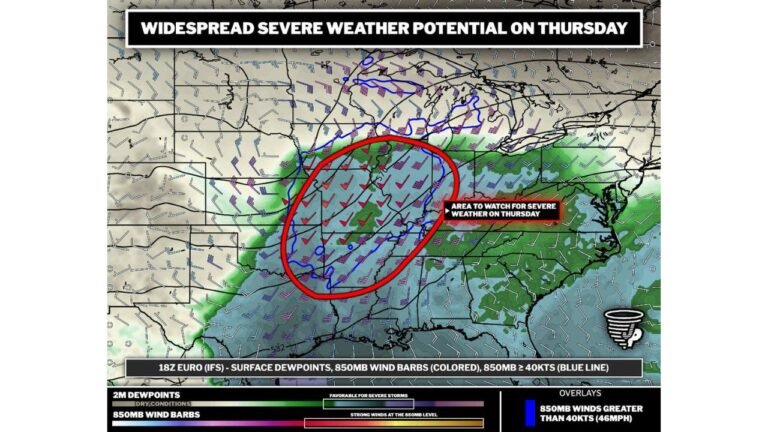
Tornado Risk Upgraded Across the Ozarks: Storm Prediction Center Adds 5% Tornado Corridor Covering Northern Arkansas and Southern Missouri
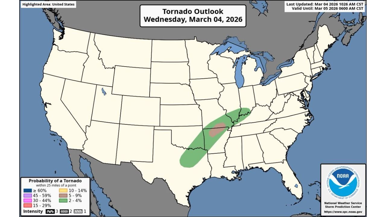
SPRINGFIELD, MISSOURI — The National Weather Service’s Storm Prediction Center (SPC) has upgraded today’s tornado outlook, introducing a 5% tornado probability corridor stretching across parts of the Ozarks, including northern Arkansas and southern Missouri.
The update signals that conditions may become favorable for isolated tornado development as storms organize across the region throughout the day.
Forecasters are urging residents within the highlighted risk area to remain weather-aware and prepared to act quickly if warnings are issued.
Tornado Risk Focused on the Ozarks Region
The newly outlined tornado corridor extends across portions of the Ozark Plateau, a region known for active spring weather patterns. According to the SPC outlook valid through early Thursday morning, the risk zone includes parts of:
- Northern Arkansas
- Southern Missouri
- Areas near Springfield, Missouri
- Communities across the Arkansas–Missouri border region
The corridor is highlighted within a broader zone of storm potential across the lower Mississippi Valley into the mid-Missouri Valley.
Meteorologists say the 5% tornado probability means that there is a measurable risk of tornadoes developing within 25 miles of any given point inside the highlighted area.
Supercells Possible as Storms Develop
Weather models indicate that clusters of thunderstorms could evolve into supercells, a type of rotating thunderstorm capable of producing tornadoes, damaging winds, and large hail.
Atmospheric conditions expected today include:
- Increasing instability
- Strong wind shear
- Moist air streaming north from the Gulf of Mexico
These ingredients can create an environment supportive of rotating storms capable of producing tornadoes, particularly during the afternoon and evening hours.
Potential for Live Severe Weather Coverage
Because of the tornado potential, weather analysts say live severe weather monitoring or livestream coverage may become necessary if storms begin producing warnings.
Storm chasers and meteorologists often monitor the Ozarks region closely during setups like this because terrain and atmospheric patterns frequently favor supercell development there during early spring.
Residents Urged to Stay Alert
Emergency management officials recommend that residents in the risk area have multiple ways to receive weather alerts, including:
- Weather radio
- Mobile alert systems
- Local broadcast updates
- Trusted weather apps
Tornado warnings can develop quickly, sometimes with little lead time, making preparedness essential.
Midwest and Mississippi Valley Entering Active Severe Weather Season
The tornado outlook arrives as severe weather season begins ramping up across the central United States, particularly through March and April.
The Ozarks, along with parts of the southern Plains and lower Mississippi Valley, often experience early-season tornado threats as warm Gulf moisture collides with advancing cold fronts.
Meteorologists will continue to monitor storm development throughout the day as conditions evolve.
For updates on severe weather threats affecting the Midwest and surrounding regions, stay connected with ChicagoMusicGuide.com for the latest forecasts and storm coverage.