Illinois, Missouri, Iowa and Arkansas Brace for Dangerous Friday Storms as Tornado Risk, 70 MPH Winds and Large Hail Threaten Region
UNITED STATES — A volatile severe weather setup is expected to unfold Friday, March 6, across parts of the Midwest and central United States, where meteorologists warn that damaging winds, large hail, and a few potentially significant tornadoes could develop as a powerful cold front pushes southeast through the region.
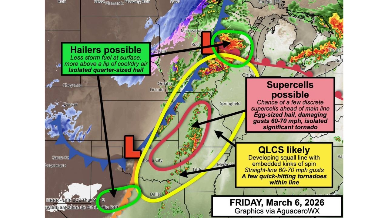
Weather analysts say the evolving storm system could create three separate zones of severe weather potential, stretching from the Upper Midwest through the Mississippi Valley and into parts of the Southern Plains.
Squall Line Could Bring 70 MPH Winds and Quick Tornadoes
The most widespread threat is expected to come from a developing squall line along the advancing cold front, which is forecast to organize and sweep southeast across the region Friday.
This line of storms could produce:
- Damaging straight-line wind gusts of 60–70 mph
- Embedded rotation within the line
- Brief but potentially dangerous tornadoes
Areas most likely to see this squall line include:
- Eastern and southeastern Iowa
- Much of central and western Illinois
- Missouri
- Northwest Arkansas
- Possibly parts of central and eastern Oklahoma
Forecasters note that mesocyclones embedded within the storm line could spin up quick tornadoes, particularly as storms interact with strong wind shear in the atmosphere.
Supercell Thunderstorms Could Produce Stronger Tornadoes
Ahead of the main storm line, conditions may also allow isolated supercell thunderstorms to develop in a corridor stretching through parts of the central Plains and Midwest.
These supercells represent the highest-end tornado risk, although they remain the biggest forecast uncertainty.
If storms can develop in this environment without being disrupted by neighboring storms, they could produce:
- Egg-sized hail
- Damaging winds
- An isolated significant tornado rated EF2 or stronger
Meteorologists emphasize that whether temperatures warm enough ahead of the cold front will determine if these discrete supercells can form.
Large Hail Possible in Wisconsin and North Texas
Two additional regions may experience hail-producing storms separate from the main tornado threat.
One of these zones is located north of the warm front in Wisconsin, where elevated thunderstorms could develop above a shallow layer of cooler surface air. These storms could produce isolated hailstones up to quarter size.
Another hail threat exists farther south along Interstate 20 in Texas, particularly between Midland–Odessa and Abilene, where atmospheric instability could also support strong hail-producing storms.
Complex Weather Pattern Driving the Outbreak
The severe weather setup is being fueled by a strong low-pressure system moving across the central United States, which is dragging a powerful cold front southeastward while drawing warm, humid air northward ahead of it.
This clash of air masses is creating a corridor of instability and wind shear, two key ingredients necessary for severe thunderstorms and tornado development.
Residents Urged to Stay Weather-Aware
Because storms may evolve quickly Friday, meteorologists are urging residents across the risk zones to remain alert throughout the day and evening.
Anyone with outdoor plans Friday night should make sure they have multiple ways to receive weather warnings, including smartphone alerts, weather radios, or local broadcast notifications.
Additional forecast updates are expected as meteorologists gain more confidence in the exact placement and intensity of the storm system.
For continued updates on major U.S. weather events and storm threats, stay connected with ChicagoMusicGuide.com.