Cincinnati, Columbus, Dayton and Wilmington, Ohio Under Sunday Severe Storm Threat as Large Hail and Damaging Winds Target the Miami Valley
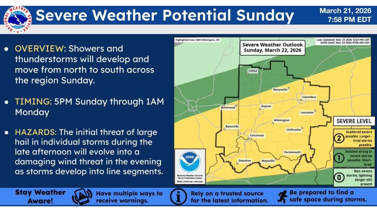
WILMINGTON, OHIO — Severe thunderstorms are expected to develop Sunday across portions of southwest and central Ohio, with the National Weather Service in Wilmington highlighting Cincinnati, Columbus, Dayton, Wilmington, Chillicothe, and Portsmouth within the primary threat zone.
Forecasters indicate no major changes in thinking regarding the setup. The main concern remains large hail during the late afternoon, transitioning into a damaging wind threat through the evening hours as storms organize into line segments.
Timing: Late Afternoon Through Early Monday
Storms are expected to develop and move north to south across the region, with the most active window projected between 5 PM Sunday and 1 AM Monday.
Initial storm development may occur during peak heating hours. As temperatures climb into the 80s, instability will build across much of southern and central Ohio, priming the atmosphere for stronger updrafts capable of producing severe hail.
Primary Hazard: Large Hail
The first storms to develop Sunday afternoon may remain more isolated. During this early phase, large hail will be the primary hazard, especially in stronger individual cells.
Cities such as Dayton, Columbus, and Cincinnati could see hail-producing storms before sunset if discrete supercells form.
Hail potential will be highest while storms remain individual and organized, prior to merging into larger clusters.
Evening Transition to Damaging Winds
As the evening progresses, storms are expected to consolidate into line segments, shifting the primary risk toward damaging straight-line winds.
Communities from Wilmington south toward Cincinnati and east toward Chillicothe and Portsmouth may experience gusty winds capable of downing trees and power lines.
The severe outlook indicates scattered severe storms are possible, with some storms potentially longer-lived.
Very Warm Conditions Fueling Instability
Unseasonably warm temperatures, with highs reaching the 80s across much of the region, will contribute to the available instability.
For late March, 80-degree readings are notably above average, enhancing the potential for robust thunderstorm development when combined with favorable wind profiles.
Storm Mode Will Determine Impact
Forecasters stress that the evolution of storms will be key. If storms remain isolated longer into the evening, hail risk could be more significant. If they quickly organize into a line, wind damage would become the dominant concern.
Residents across southwest and central Ohio are urged to stay weather aware, have multiple ways to receive warnings, and identify safe shelter locations ahead of the evening threat.
As conditions develop Sunday, updates and possible watches or warnings may be issued.
For continuing coverage of severe weather threats across the Midwest and beyond, stay with ChicagoMusicGuide.com.