Baltimore Washington Richmond And Philadelphia Face Potential 90 Degree Heat Surge Next Week As Mid Atlantic Warms Toward Record April Temperatures
BALTIMORE, MARYLAND — A powerful surge of unseasonably warm air is expected to push temperatures sharply higher across the Mid-Atlantic, with cities like Baltimore, Washington D.C., Richmond, and Philadelphia potentially nearing or even reaching 90 degrees next week, putting long-standing April records into focus.
Record Level April Heat Possible Across Baltimore And Surrounding Cities
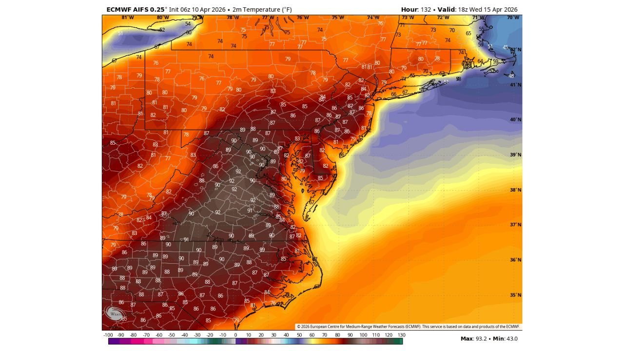
Historical data shows that Baltimore’s warmest April temperature on record is 94°F, a mark reached multiple times in the past. With the upcoming pattern, forecasters indicate that temperatures approaching 90°F are increasingly possible, especially by midweek, with Wednesday emerging as the most favorable day for peak heat.
This warming trend will not be isolated to Baltimore alone. Nearby urban centers including Washington D.C., Richmond, and Philadelphia are also expected to experience significant temperature spikes, with widespread highs climbing into the upper 80s to near 90°F range.
Such values are well above normal for April and would represent early-season heat more typical of late spring or even early summer.
Strong Warm Air Mass Driving Temperature Surge
The heat buildup is being driven by a strong and expansive warm air mass spreading across the eastern United States. This system is allowing southerly winds to transport warmer air northward, creating a broad zone of elevated temperatures across the Mid-Atlantic and Northeast corridor.
Areas inland, particularly around central Maryland and northern Virginia, may see the most intense warming, where temperatures could push closest to the 90-degree threshold.
Meanwhile, coastal areas such as parts of New Jersey and eastern Long Island may remain slightly cooler due to marine influences, but even there, above-normal warmth is expected.
Midweek Timing Key For Peak Heat Impact
Forecast trends suggest that Wednesday will likely be the peak day of this heat event, when atmospheric conditions align for maximum warming.
During this period:
- Baltimore and Washington D.C. could approach or exceed 90°F
- Richmond may also see upper 80s to near 90°F readings
- Philadelphia could reach the mid to upper 80s, with isolated hotter spots
This timing is important as it reflects the strongest influence of the warm air ridge settling over the region, maximizing daytime heating potential.
Early Season Heat Raises Awareness Across Region
An early-season heat surge of this magnitude can catch residents off guard, especially after a relatively mild spring start. The sudden jump in temperatures may impact outdoor activities, travel plans, and daily routines across major cities.
Additionally, such warm conditions this early in the season may lead to:
- Increased demand for cooling systems
- Stress on urban infrastructure and road surfaces
- Early strain on energy usage patterns
While not unprecedented, approaching record temperatures in April highlights how dynamic and rapidly changing spring weather patterns can be across the Mid-Atlantic.
What Residents Should Watch Moving Forward
Residents across Baltimore, Washington D.C., Richmond, and Philadelphia should continue monitoring updates as the forecast evolves, particularly regarding:
- Whether 90°F will be officially reached or exceeded
- How long the warm spell will persist
- Any potential changes in cloud cover or wind direction that could influence temperatures
With conditions aligning for a potentially notable warm event, this period could become one of the most significant early-season heat episodes of the year so far.
For more updates on regional weather trends, seasonal outlooks, and major forecast shifts, visit ChicagoMusicGuide.com for continued coverage and in-depth reports.