Thursday April 23 Severe Weather Setup Takes Shape as Oklahoma City and Wichita Face the Strongest Threat While Eastern Minnesota and Wisconsin Enter the Risk Zone
KANSAS CITY, MO — The severe weather setup taking shape for Thursday, April 23, 2026 is coming into clearer focus, and the latest model guidance is pointing toward a two-corridor threat that puts Oklahoma City and Wichita inside the highest-risk zone while simultaneously expanding the threat northward into eastern Minnesota, west-central Wisconsin, and potentially northwest Illinois.
The key atmospheric driver is a low-pressure system that current analysis shows tracking progressively northward into Canada by Thursday — a track that sets up the classic warm sector severe weather environment across the central Plains and Upper Midwest simultaneously.
How the Thursday Setup Is Organized
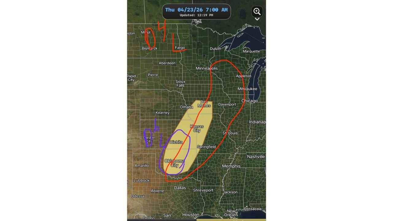
The map valid for Thursday, April 23 at 7:00 AM shows two distinct risk areas already being drawn by forecasters, each carrying different threat profiles and confidence levels.
The southern corridor — shown in yellow shading — covers a zone from Oklahoma City northward through Wichita and into the Kansas City and Des Moines corridor. This is the primary and highest-confidence severe weather target for Thursday. A purple oval drawn over Oklahoma City and Wichita highlights the area where the most organized and potentially most dangerous storm activity is expected. Current analysis indicates this zone sits in the deepest portion of the warm sector ahead of the approaching system, where moisture, instability, and wind shear will be most concentrated by Thursday afternoon and evening.
The northern corridor — outlined in red — extends from the southern target zone northward through Minneapolis and into eastern Minnesota and west-central Wisconsin. This is the area where a slight risk extension is being considered as the low-pressure track pushes the severe weather environment further north than initially expected. Northwest Illinois is also flagged as a possible inclusion in this northern risk zone as the system evolves.
A separate hand-drawn annotation near Bismarck and Fargo with a circled 4 and vertical marks indicates the cold side of the system — where cooler air and potentially snow or wintry precipitation may develop across North Dakota on the northwest flank of the departing low by Thursday morning.
Thursday Risk Zone Summary
| Zone | Risk Level | Key Cities | Primary Threats |
|---|---|---|---|
| Southern Core (Purple oval) | Highest | Oklahoma City, Wichita | Organized severe storms, all hazards |
| Central Corridor (Yellow) | Elevated | Kansas City, Des Moines, Springfield | Severe thunderstorms, hail, wind |
| Northern Extension (Red circle) | Slight potential | Minneapolis, eastern Minnesota, W-C Wisconsin | Severe storms if system tracks north |
| Northwest Illinois | Possible inclusion | Rockford fringe | Conditional on system evolution |
| North Dakota (Bismarck, Fargo) | Cold/wintry | Bismarck, Fargo, Minot | Snow or wintry mix on cold side |
State-by-State Breakdown
Oklahoma — Oklahoma City and Surrounding Areas Oklahoma City sits inside the purple highest-risk oval for Thursday. Current analysis places this zone at the bullseye of the warm sector for the April 23 event, where the combination of Gulf moisture, atmospheric instability, and wind shear will be most concentrated. Organized severe thunderstorms capable of producing large hail, damaging winds, and tornadoes are all possible across central Oklahoma Thursday afternoon and evening.
Kansas — Wichita and Kansas City Corridor Wichita shares the highest-risk oval with Oklahoma City, placing it inside the same concentrated severe weather environment Thursday. Kansas City falls within the broader yellow corridor where severe thunderstorms are expected. Large hail and damaging winds are the primary threats across Kansas, with tornadoes possible particularly across the Wichita corridor where the warm sector environment will be deepest.
Iowa and Missouri — Des Moines, Kansas City and Springfield The yellow risk corridor extends northward through Des Moines and into the Kansas City and Springfield area. Severe thunderstorms are expected across this corridor as storms organize and track northeastward through Thursday afternoon and evening.
Minnesota — Eastern and Twin Cities The potential extension of a slight risk into eastern Minnesota and the Minneapolis area is one of the more notable developments in Thursday’s evolving setup. The low-pressure track pushing toward Canada by Thursday will drag the warm front northward into Minnesota, potentially bringing severe weather conditions to the Twin Cities corridor. This remains a watch-and-see area with confidence building through midweek.
Wisconsin — West-Central West-central Wisconsin is flagged for potential slight risk inclusion as the northern extent of Thursday’s severe weather environment expands. Communities across this corridor should monitor forecast updates through Tuesday and Wednesday as the system’s track becomes more defined.
Illinois — Northwest Northwest Illinois including the Rockford fringe is mentioned as a possible inclusion in the northern risk zone. The exact placement of the warm front boundary Thursday will determine whether organized severe weather reaches this far east across northern Illinois.
North Dakota — Bismarck and Fargo The cold side of the departing low brings a very different story to North Dakota. Bismarck, Fargo, and Minot are on the northwest flank of the system where wintry precipitation including snow is possible Thursday — a stark contrast to the severe thunderstorm environment developing to the south and east simultaneously.
Forecast Confidence
Confidence: Low to Moderate — appropriate for a severe weather setup still four days away. The Oklahoma City and Wichita southern core carries the strongest confidence of any location in Thursday’s outlook, with multiple model runs consistently placing the warmest and most unstable air over this corridor. The Minnesota and Wisconsin northern extension carries lower confidence and is subject to significant adjustment as the low-pressure track becomes better defined through midweek model runs.
Residents across Oklahoma City, Wichita, Kansas City, Des Moines, Minneapolis, and west-central Wisconsin should track forecast updates daily through Wednesday as Thursday’s setup comes into sharper focus.
More multi-day severe weather outlook coverage is always on the horizon. Stay informed at ChicagoMusicGuide.com — your source for storm tracking across Oklahoma, Kansas, Minnesota, Wisconsin, and the entire United States.