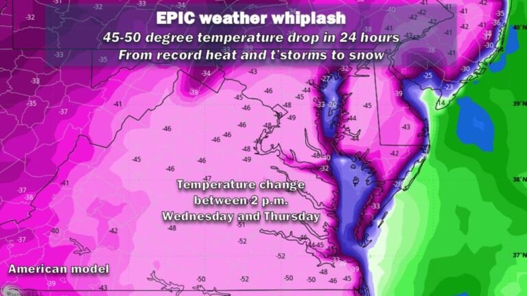
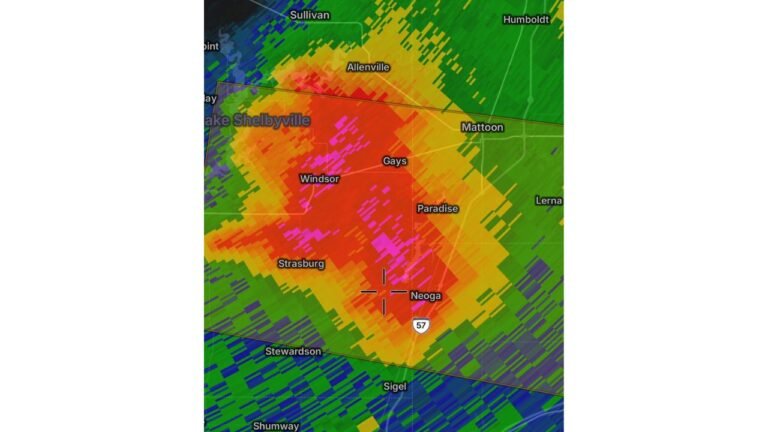
Illinois Has Been the Most Targeted State for Severe Weather in 2026 as a Stunning Heatmap Shows 36 Outbreak Days Already Logged Across the Central and Eastern United States Through April 18
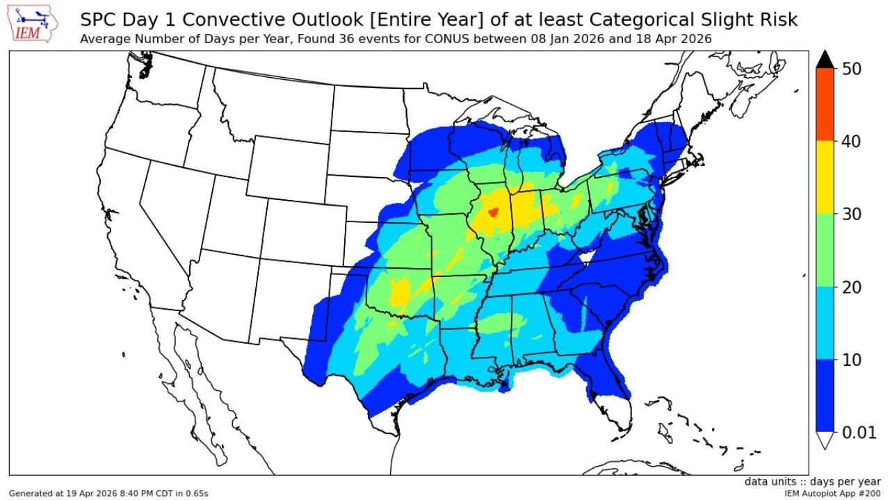
CHICAGO, IL — A striking heatmap of every Storm Prediction Center Day 1 Outlook carrying at least a Slight Risk of severe weather between January 8 and April 18, 2026 has been released — and the picture it paints of where severe weather has hammered the United States hardest so far this year is both dramatic and historically significant.
36 separate severe weather outlook days have been recorded across the continental United States in just over three months. The heatmap showing where those days overlapped reveals a bullseye that most residents of the central United States will recognize immediately: Illinois, Indiana, Kentucky, Tennessee, and the broader Ohio Valley corridor have been the most repeatedly targeted region for organized severe weather in the country so far in 2026.
What the Heatmap Is Showing
The color scale on this map runs from near-zero in white and light blue up through 50 days per year in deep orange and red. Every shade of color represents how many of the 36 outbreak days included a Slight Risk or greater designation covering that specific location.
The red bullseye — the single most severe-weather-targeted location in the entire country through April 18 — is positioned over central Illinois and western Indiana, covering roughly the Springfield, Illinois to Indianapolis corridor. This zone has been inside a Slight Risk or higher severe weather outlook on the greatest number of days of any location in the continental United States so far in 2026.
Surrounding that red core, a broad orange and yellow zone covers Illinois, Indiana, Ohio, Kentucky, Tennessee, Missouri, and extends into Arkansas, Mississippi, and western Pennsylvania. These areas have been inside elevated severe weather outlooks on 25 to 45 days of the 36 total outbreak days logged so far this year.
A wide green zone extends the above-average severe weather coverage across Iowa, Wisconsin, Michigan, Virginia, North Carolina, Alabama, Louisiana, and Texas. The light blue outer ring reaches Minnesota, Georgia, Florida, New York, and New England.
The entire western United States — every state west of the Great Plains — shows essentially zero severe weather outlook coverage through April 18. California, Oregon, Washington, Nevada, Utah, Colorado, Idaho, Montana, Wyoming, Arizona, and New Mexico all sit in the white near-zero zone, confirming that 2026’s severe weather pattern has been almost exclusively an eastern half of the country story.
2026 Severe Weather Heatmap by Region
| Color Zone | Days in Outlook | Key States and Cities |
|---|---|---|
| Red Bullseye | 45 to 50+ days | Central Illinois, Western Indiana — Springfield, Indianapolis |
| Orange | 35 to 45 days | Illinois, Indiana, Ohio, Kentucky, Tennessee, Missouri |
| Yellow | 25 to 35 days | Arkansas, Mississippi, western Pennsylvania, Iowa fringe |
| Green | 15 to 25 days | Wisconsin, Michigan, Virginia, N. Carolina, Alabama, Louisiana |
| Cyan/Light Blue | 5 to 15 days | Minnesota, Georgia, Florida, New York, New England, Texas |
| White/Near Zero | 0 to 1 days | All western states |
State-by-State Breakdown
Illinois No state in the country has been more consistently placed inside severe weather outlooks in 2026 than Illinois. The red bullseye sits directly over central Illinois, and the orange zone covers virtually the entire state. Chicago, Springfield, Rockford, Peoria, and communities statewide have been inside Slight Risk or greater outlooks on a remarkable number of days already this year — and the severe weather season is only entering its peak months.
Indiana and Ohio Indiana shares the orange high-frequency zone with Illinois, with Indianapolis sitting just east of the red core. Ohio falls in the orange to yellow range, with Columbus, Cleveland, and Cincinnati all accumulating significant severe weather outlook days through April 18. The Ohio Valley corridor has been one of the most consistently active severe weather regions in the country this year.
Kentucky and Tennessee Both states fall inside the orange zone, with Louisville, Lexington, Nashville, and Memphis all accumulating elevated severe weather outlook day counts. Tennessee has been particularly active, sitting at the intersection of Deep South and Ohio Valley storm tracks throughout early 2026.
Missouri and Arkansas St. Louis and Kansas City in Missouri sit in the orange zone. Arkansas falls in the yellow to orange range — though as noted in current analysis, the state has been unusually quiet for actual severe weather impacts despite the outlook day count, a pattern that forecasters expect to change heading into late April.
Mississippi, Alabama and Louisiana The Deep South states fall in the yellow to green range, reflecting their position on the southern end of the most active storm tracks so far in 2026. Jackson, Birmingham, and New Orleans have been inside outlooks frequently but slightly less often than the core Midwest and Ohio Valley corridor.
Wisconsin and Michigan Both states fall in the green zone — consistent with the significant severe weather activity that has struck Wisconsin in particular during April 2026, including last week’s historic 23-tornado outbreak that produced three EF-3 tornadoes.
Western United States Zero. The heatmap is unambiguous: California, Oregon, Washington, and every state west of the Plains have recorded essentially no severe weather outlook coverage through April 18, 2026. The entire severe weather pattern this year has been locked to the eastern half of the country.
Forecast Confidence
This is confirmed historical data, not a forecast. The heatmap represents the official record of every Storm Prediction Center Day 1 Outlook carrying at least a Slight Risk designation across the continental United States between January 8 and April 18, 2026 — a total of 36 separate outbreak days. The geographic distribution shown is a verified record of where organized severe weather has been most repeatedly threatened and delivered across the country in the first three and a half months of the year.
With the peak of severe weather season — late April through June — still ahead, the regions already sitting in the orange and red zones of this heatmap face continued elevated exposure through the remainder of spring.
More severe weather pattern and outbreak tracking coverage is always on the horizon. Stay informed at ChicagoMusicGuide.com — your source for severe weather heatmaps and outbreak analysis across Illinois, Indiana, the Ohio Valley, and the entire United States.