Supercell Thunderstorms With Several Tornadoes and Cyclic Nighttime Tornado Threat Target Central Oklahoma and Tulsa Sunday Afternoon Through Overnight
OKLAHOMA CITY, OK — The atmosphere over central Oklahoma is coiling tighter by the hour. A broad field of cumulus clouds — the towering white building blocks that signal a destabilizing atmosphere — has been expanding across the region through Sunday afternoon, and current analysis indicates the trigger needed to break the remaining cap and ignite severe thunderstorms is expected to arrive within the next couple of hours. When it does, the storm environment waiting underneath is primed for a significant and potentially dangerous overnight severe weather event.
This is not just an afternoon threat. The tornado risk here extends well into the nighttime hours — and that makes this setup considerably more dangerous for communities across Oklahoma.
What the Atmosphere Is Loaded With Right Now
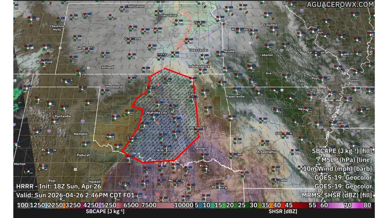
High-resolution model data valid for Sunday, April 26, 2026 at 2:46 PM CDT shows surface-based instability values — SBCAPE, which measures the explosive energy available to storms drawing from the lowest layers of the atmosphere — running between 4,250 and 5,250 joules per kilogram across the core of central Oklahoma. The highest values are concentrated in a broad zone centered over Oklahoma City, Tulsa, McAlester, and Ardmore, with the instability plume extending from near Enid in the north down through the Red River corridor in the south.
The hatched red outline on current analysis maps defines the highest-risk severe weather zone — a region spanning from near Enid and Woodward in the northwest, through Oklahoma City and Tulsa, down to the Ardmore and Antlers corridor in the south. This is where storm initiation and the greatest tornado threat are concentrated for Sunday afternoon and evening.
The Nocturnal Tornado Threat and Why It Is Especially Dangerous
Current analysis flags a scenario that forecasters treat with particular caution: the cyclic tornado-producing supercell threat extending through the overnight hours. A cyclic supercell is a thunderstorm that produces multiple tornadoes in sequence — the storm’s rotation reorganizes repeatedly, spinning up new tornadoes as old ones dissipate, potentially for hours at a time.
Deviant motion — a behavior where supercells travel at angles significantly different from the surrounding storm environment — is considered possible tonight. Supercells exhibiting deviant motion are especially difficult to track and warn for because their movement is less predictable. Combined with overnight darkness, which eliminates the ability for residents to visually spot approaching tornadoes, this creates a scenario where warning lead times become critically important.
The threat window here is not just a two or three hour afternoon severe weather event. Current data suggests the severe and tornado threat will persist through the nocturnal hours, meaning communities across central and eastern Oklahoma could face tornado-warned storms well into Sunday night and early Monday morning.
Atmospheric Sounding Data — What the Upper Air Profile Shows
The atmospheric sounding data for Monday, April 27 at 01Z — which is Sunday evening in local time — valid near the Oklahoma-Kansas border region at approximately 36.8 degrees North, 94.7 degrees West, reveals an extraordinarily dangerous storm environment. Key values from the sounding analysis include:
CAPE of 3,972 joules per kilogram with CINH — the inhibition or cap resisting storm development — at only -7, meaning the atmosphere is nearly uncapped and ready to explode. Significant Tornado Parameter — a composite index combining multiple ingredients that forecasters use to assess violent tornado probability — is reading 1.8, a value associated with environments that support significant tornadoes. Supercell Composite is reading 26.29, an extraordinarily high value. Storm-Relative Helicity in the lowest kilometer of the atmosphere is at 457 meters squared per second squared, indicating extreme low-level rotation potential. 0 to 6 kilometer bulk wind shear is at 95 meters per second squared, providing the deep-layer shear needed for long-lived supercell organization.
The sounding analog matches — which compare today’s atmospheric profile to historical storm events — are flagging PDS TOR hazard type. PDS stands for Particularly Dangerous Situation, the highest-tier tornado watch designation. This does not get issued lightly.
Updraft Helicity and Storm Rotation Signals
Model data valid for Sunday evening at 9:00 PM CDT shows 3km Maximum Updraft Helicity — a model-derived measurement of how much rotation is occurring inside storm updrafts — spiking across the Oklahoma City, McAlester, Ada, and Ardmore corridors. The highest helicity tracks shown on current analysis paint a picture of multiple discrete supercells rotating aggressively across central and southeastern Oklahoma through the evening hours.
The 3km EHI — Energy Helicity Index, which combines instability and rotation potential into a single number — is reading 5 to 12 across portions of central Oklahoma. Values above 1 are considered supportive of tornadoes. Values above 5 are associated with violent tornado potential.
Threat and Data Summary Table
| Parameter | Value | Significance |
|---|---|---|
| Peak SBCAPE | 4,250 to 5,250 J/kg | Extremely explosive atmosphere |
| CAPE (Sounding) | 3,972 J/kg | Very high instability |
| Storm-Relative Helicity (0-1km) | 457 m2/s2 | Extreme low-level rotation |
| Significant Tornado Parameter | 1.8 | Significant tornado environment |
| Supercell Composite | 26.29 | Extraordinary supercell support |
| 3km EHI | 5 to 12 | Violent tornado potential |
| Hazard Type (SARS analog) | PDS TOR | Particularly Dangerous Situation |
| Threat Duration | Afternoon through overnight | Nighttime tornado risk elevated |
| Cyclic Supercell Risk | Possible with deviant motion | Multiple tornadoes from single storm |
Area Impact Assessment
Oklahoma City metro and central Oklahoma — Directly inside the highest instability and rotation zones. Afternoon storm initiation expected within this corridor. Tornado-warned supercells are likely through the evening and overnight hours. Every resident should have shelter identified and warnings actively monitored.
Tulsa and northeast Oklahoma — Within the hatched severe zone on current analysis. Storm activity from the west will push into this corridor through the afternoon and evening. Tornado threat is real and significant.
McAlester, Ada, and southeast Oklahoma — High updraft helicity tracks shown in current model data target this area specifically for rotating supercell activity Sunday evening. Cyclic tornado potential is a particular concern here through the overnight hours.
Ardmore and southern Oklahoma — Southern fringe of the primary instability plume. Storms developing in the Red River corridor could impact this area, particularly during the afternoon initiation window.
Enid and north-central Oklahoma — Northern edge of the severe weather zone. Still within the hatched risk area. Tornado-warned storms possible, particularly during the afternoon hours.
Forecast Confidence
Confidence in significant severe weather including multiple tornadoes across central and eastern Oklahoma Sunday afternoon and evening is HIGH. The atmospheric data — instability values, helicity readings, sounding profiles, and model storm rotation signals — are all in exceptional agreement. Confidence in the cyclic overnight tornado threat is MODERATE to HIGH contingent on whether robust supercells can sustain themselves against increasing low-level inhibition after dark. Confidence in the PDS-level tornado environment across the Oklahoma City and McAlester corridors is HIGH.
Tonight is not the night to sleep through weather alerts. Keep your phone charged, keep notifications active, and know exactly where your shelter is before you go to bed Sunday evening.
More severe weather coverage is always on the horizon. Stay informed at ChicagoMusicGuide.com — your source for supercell tracking, overnight tornado coverage, and breaking severe weather alerts across Oklahoma and the entire United States.