Maryland, Delaware, Pennsylvania, and Washington D.C. Bracing for Sunday Snow Band Bringing 2–4 Inches to the Urban Corridor
BALTIMORE, MARYLAND — Sunday System Targets Mid-Atlantic With a Plowable Snowfall, A developing winter system is lining up to bring measurable snow on Sunday across parts of Maryland, Delaware, south-central Pennsylvania, and the Washington D.C. metro area, potentially impacting church services, matinee shows, and evening events just as the busy pre-holiday weekend winds down.
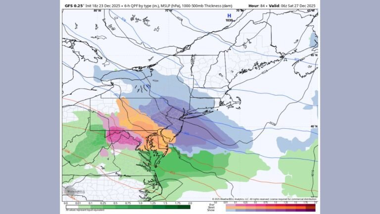
Multiple forecast projections clustered late Wednesday night point to a long, narrow band of steady snow sweeping from the mountains of western Maryland through the Baltimore–Washington corridor and into Delaware and southern New Jersey.
Where the Heaviest Snow Is Currently Expected
While exact totals will shift as the storm gets closer, the latest guidance suggests a clear pattern:
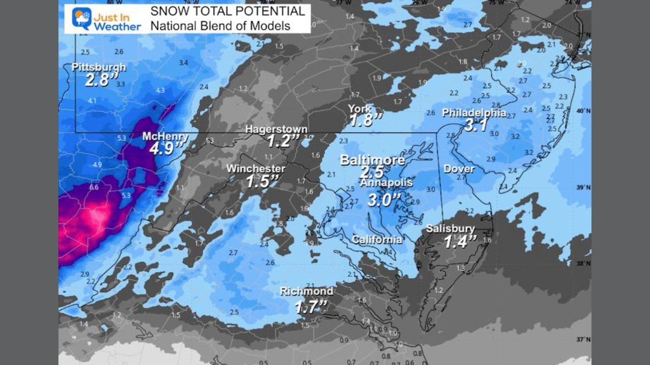
- In western Maryland, especially around McHenry and the higher ridges, some scenarios show 4–7 inches of snow, making this area the likely jackpot zone.
- Across the Baltimore–Annapolis–Washington D.C. corridor, several projections converge on about 2–4 inches, enough to cover roads and sidewalks and require plowing in many neighborhoods.
- Farther northeast into Dover and Philadelphia, amounts generally range from around 3 inches, with some projections a bit higher or lower depending on the track.
- Toward the southern edge of the band, including Richmond, Virginia, totals are lower but still notable, hovering near 1–2 inches in many scenarios.
- Eastern Shore communities such as Salisbury and California, Maryland, repeatedly show around 1–4 inches, with slightly higher amounts possible in any heavier bands.
Forecasters emphasize that these numbers are early estimates, but the overall signal points to a widespread light-to-moderate snow event rather than a huge blizzard.
Why the Numbers Differ From Map to Map
The graphic set shows four different projections of “snow total potential” for the same Sunday system. Each one handles the exact strength, timing, and track of the storm a little differently, which is why McHenry, for example, ranges from about 3 to 7 inches, and Baltimore varies from about 2½ inches in one scenario to nearly 4 inches in another.
A common rule of thumb used by forecasters is to avoid fixating on the single highest or lowest forecast. Instead, they look toward the middle of the range, then adjust expectations as new data arrives and the storm draws closer.
For residents and performers, that means planning around a solid chance of enough snow to coat everything and affect travel, even though the final total at your house might end up a bit higher or lower than any one map shows.
Timing: Sunday Event Could Hit Travel and Shows
The snow is expected to arrive Sunday and continue through the day and into the evening, depending on location. That timing could affect:
- Morning church services and community events
- Afternoon concerts, rehearsals, and soundchecks
- Evening club shows and arena performances across Baltimore, D.C., and surrounding suburbs
Road crews will likely be out early, but slushy and slick conditions are possible on untreated surfaces, especially in areas that pick up 2–4 inches or more.
What This Means for Fans, Musicians, and Venues
For the Mid-Atlantic music community, even a moderate snowfall can ripple through the schedule:
- Allow extra time to reach venues, studios, or rehearsal spaces on Sunday.
- Check with promoters and venues for any adjustments to door times or show schedules if roads become hazardous.
- Load in and out carefully, as sidewalks, loading docks, and backstage alleys could be covered in snow or ice by evening.
- For touring acts driving between cities, be aware that conditions may be worse in western Maryland and the higher terrain than in the big urban centers.
Staying Ready as the Forecast Fine-Tunes
As new data comes in, total projections will continue to shift by an inch or two in either direction, but the current signal is clear: a meaningful Sunday snow is increasingly likely from western Maryland through Baltimore, Washington D.C., and into Delaware and southeastern Pennsylvania.
ChicagoMusicGuide.com will keep tracking the forecast and what it means for concerts, festivals, and local shows across the region.
Before you head out to a gig, rehearsal, or holiday event this Sunday, check back here for updated coverage so you can plan your route, dress for the weather, and keep the music going safely no matter what the snow brings.