Maryland, Virginia, and Washington D.C. Braced for Mid-December Arctic Cold as Wind Chills Turn Dangerous by Sunday
WASHINGTON, D.C. – A powerful surge of Arctic air is forecast to sweep southward into the Mid-Atlantic by Sunday, bringing near-record cold temperatures and dangerous wind chills to Maryland, Virginia, and the Washington D.C. metro area, according to national weather guidance.
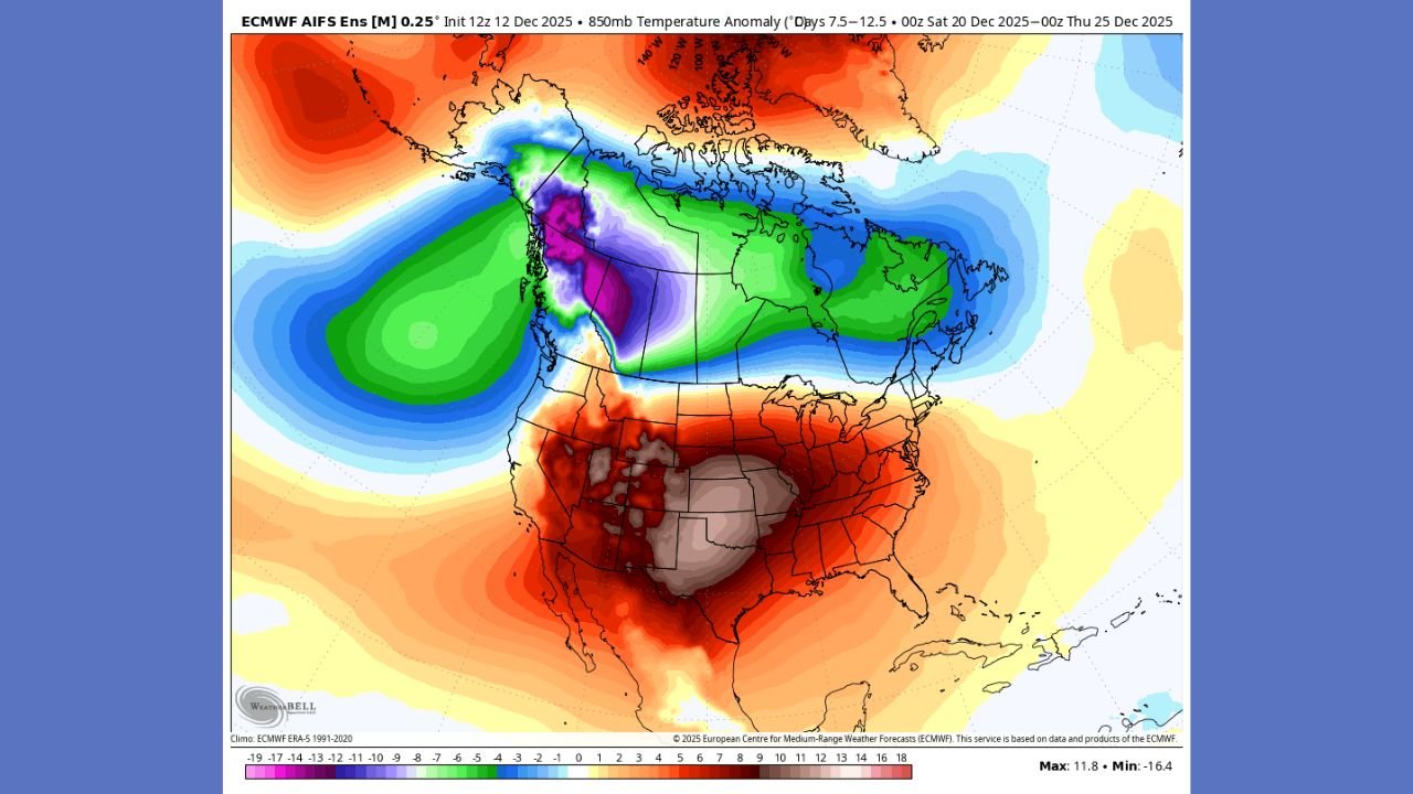
Forecast messaging shows the cold outbreak originating in the Northern High Plains late Friday before expanding into the Central Plains and Ohio Valley on Saturday, then reaching the Mid-South and Mid-Atlantic on Sunday. Once established, the cold is expected to linger into early next week, increasing the risk of prolonged exposure to extreme cold conditions.
How the cold will arrive in the Mid-Atlantic
The evolving weather pattern indicates a steady southeastward push of Arctic air rather than a brief frontal passage. By Sunday, much of the Mid-Atlantic will be locked into below-normal temperatures, with cold air deepening overnight and during the early morning hours.
This type of setup typically results in strong northwest winds behind the advancing cold front, allowing wind chill values to fall rapidly even when snowfall is limited or absent.
What temperatures and wind chills could feel like
National guidance highlights temperatures running 20 to 30 degrees below seasonal averages, with wind playing a major role in how severe conditions feel on the ground. Gusty winds—commonly 20 to 35 mph in Arctic outbreaks—are expected to accompany the cold air mass.
Across Maryland, Virginia, and Washington D.C., wind chills near or below 0°F are possible, especially during overnight and early morning periods from Sunday into early next week. Areas farther west and north may experience even colder apparent temperatures.
Impacts on travel, events, and outdoor plans
For residents attending concerts, sporting events, or commuting through the region, the cold may significantly affect comfort and safety:
- Transit exposure: Waiting at Metro stations, bus stops, or outdoor platforms could become dangerous without proper layers.
- Road travel: Cold air increases the risk of black ice during overnight hours, especially on bridges and untreated roads.
- Event conditions: Outdoor queues, security lines, and parking walks could be the coldest part of the night.
- Power strain: Extended cold increases energy demand, which can stress local infrastructure.
Even routine errands may require extra planning once wind chills drop into hazardous territory.
Why forecasters are urging preparation now
Weather officials warn that dangerous wind chills can cause frostbite and hypothermia on exposed skin in a short time. The risk increases for anyone spending extended periods outdoors, including unhoused individuals, outdoor workers, and those attending late-night events.
Recommended precautions include:
- Dressing in multiple layers with wind-blocking outerwear
- Covering hands, ears, and face
- Limiting outdoor exposure during the coldest hours
- Ensuring pets and livestock are protected
- Keeping emergency cold-weather supplies in vehicles
What could still change in the forecast
While the arrival of Arctic air is considered likely, forecasters continue monitoring exact wind strength and duration, which will determine how long the most dangerous wind chills persist. Any additional precipitation could worsen travel conditions if surfaces freeze.
Residents across the Mid-Atlantic should stay alert for updated advisories and local warnings as the cold settles in.
If you’re heading out this weekend or planning to attend shows or events, will the cold change your plans—or just your wardrobe? Share your experience and keep following ChicagoMusicGuide.com for weather-aware planning and regional updates.