
Florida Faces Coldest Air of the Season as Arctic Pattern Push Brings Freeze and Frost Risk Statewide
FLORIDA — After an unusually warm stretch to start January, a significant pattern shift is now underway that will send some of the coldest air of the winter so far into the Sunshine State later this week. Forecast guidance shows a strong surge of Arctic air pushing deep into the Southeast, setting the stage for near-freezing temperatures, widespread frost risk, and sharp wind chills across much of Florida.
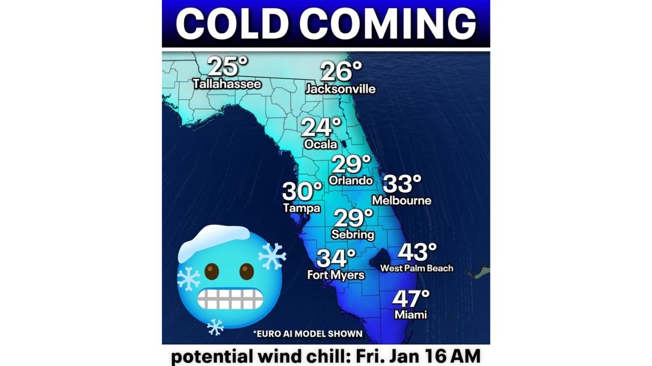
Forecast maps show cold air spreading south behind a departing storm system, with Friday morning shaping up as the coldest period for many locations. While Florida is no stranger to brief cold snaps in winter, the magnitude and coverage of this event stand out compared to recent weeks.
Temperatures Could Dip Below Freezing in Central and North Florida
Model data highlights overnight lows in the 20s and low 30s across much of northern and central Florida. Cities such as Ocala, Tallahassee, Jacksonville, Orlando, and Tampa are all shown with temperatures either near or below freezing in the coldest pockets.
Even areas farther south are not immune. Fort Myers, West Palm Beach, and Miami remain warmer than inland locations, but still appear likely to experience unseasonably cold mornings, especially with persistent winds adding a noticeable chill.
Wind Chills Add to the Cold Impact
In addition to low temperatures, gusty winds behind the cold front will make conditions feel even colder. Wind chill values are projected to fall into the 20s across central Florida, a notable departure from typical January conditions in the region.
These values are especially concerning for early morning hours, when temperatures bottom out and winds remain elevated. Outdoor events, morning commutes, and agricultural interests may all be affected.
Frost and Freeze Risk Increases for Sensitive Areas
With temperatures dipping near or below freezing, frost and freeze potential is becoming a key concern. Inland communities are most at risk, particularly areas away from coastal moderation.
Sensitive vegetation, pets, and exposed pipes could be impacted if temperatures remain below freezing for extended periods. Forecasters note that small shifts in wind or cloud cover could influence how cold individual locations ultimately get.
Confidence High in Cold, Still Refining Exact Numbers
While confidence is high that a notable cold outbreak will occur, meteorologists caution that exact temperature values may still shift as the event approaches. Adjustments of a few degrees warmer or colder are common with setups like this, especially in Florida’s diverse microclimates.
Forecasters will continue fine-tuning temperature and wind forecasts through midweek as higher-resolution data becomes available.
What Happens Next
The cold snap is expected to be short-lived, with gradual moderation returning after the coldest morning passes. However, this event serves as a reminder that winter is far from over, even in Florida, and sharp temperature swings remain possible through the remainder of January.
Stay prepared, especially if you have early morning plans or temperature-sensitive concerns, and continue monitoring updated forecasts as the cold air arrives.