
Kentucky Braces for Powerful Arctic Blast Next Weekend as Models Show Deep Freeze Spreading Across the Eastern U.S.
LOUISVILLE, KY — A Major Arctic Outbreak Could Deliver the Coldest Air of the Season Next Weekend, Louisville and much of Kentucky are positioned directly under the core of a major arctic blast expected to sweep into the Eastern United States next weekend, according to new ECMWF model data released Saturday.
Meteorologists warn that this may be the coldest air mass of the winter season so far, with morning lows dropping into the 10s and 20s across Kentucky and surrounding states.
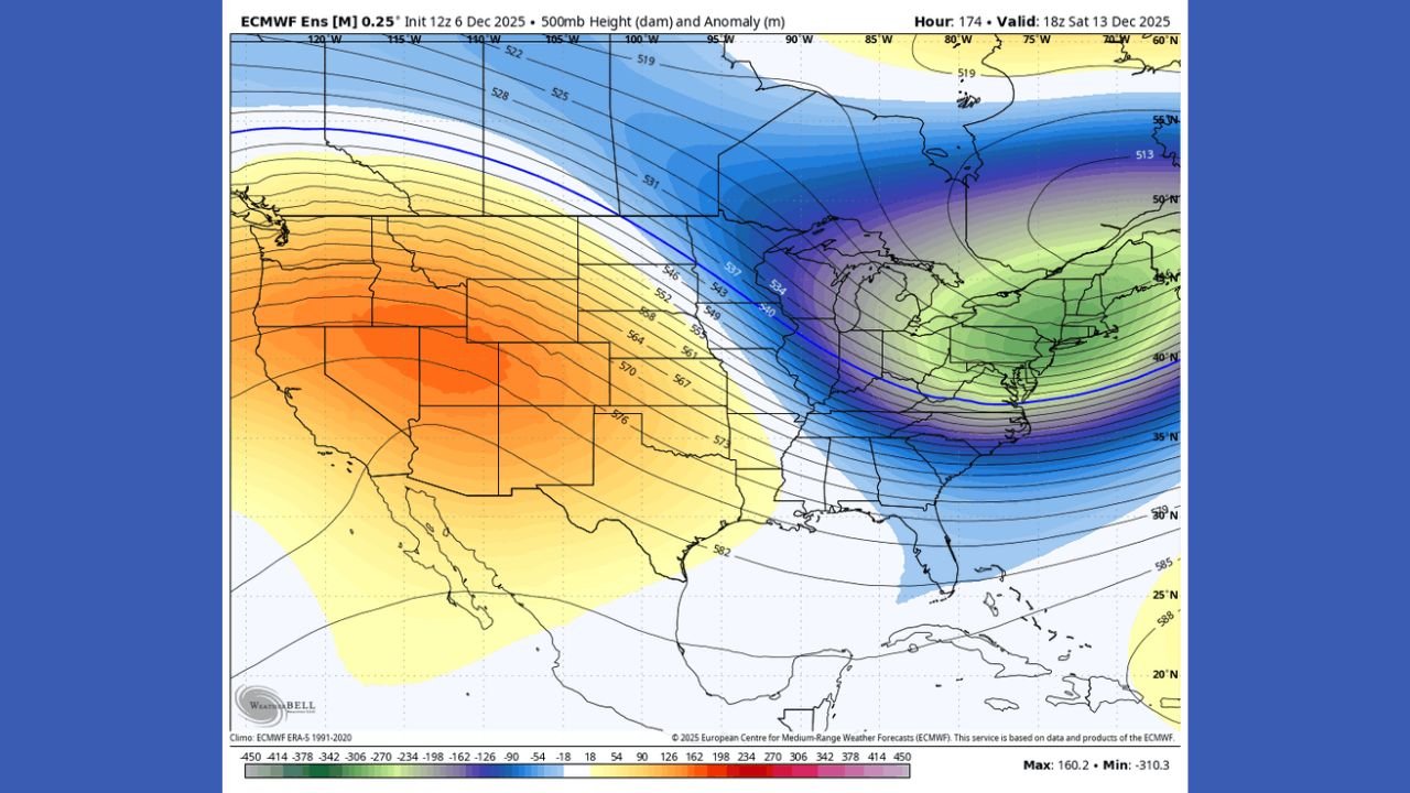
The upper-air pattern shows a strong, digging trough funneling bitter Canadian air deep into the Midwest, Ohio Valley, and eventually the East Coast — with Kentucky sitting at the center of the most significant temperature plunge.
Model Maps Highlight Deep Trough Over Kentucky Driving the Cold Surge
500mb height anomaly maps show a sharply defined negative anomaly centered across:
- Kentucky
- Indiana
- Ohio
- Tennessee
This pattern creates an ideal pathway for arctic air to surge southward, ensuring that Kentucky receives one of the most intense early-winter cold waves of the month.
Temperature Anomalies Show Kentucky Up to 20–30°F Below Normal
The ECMWF 2-meter anomaly map for December 13 shows a deep purple core centered over Kentucky:
- Central & Eastern Kentucky: 20–30°F below normal
- Western Kentucky: 15–20°F below normal
- Ohio, Indiana, Tennessee: 15–25°F below normal
- Mid-Atlantic states: 10–20°F below normal
Such widespread anomalies will create dangerous overnight cold, with wind chills dipping into the single digits in some areas.
Snow Possible for the Midwest From an Alberta Clipper
A compact Alberta Clipper may track across the Midwest, bringing light snow to:
- Illinois
- Indiana
- Ohio
- Michigan
- Possibly northern Kentucky
Expected impacts include:
- Fast-moving bursts of snow
- Strong winds
- Reduced visibility
- Slick road conditions
Meanwhile, the Southeast appears on track for a dry but sharp blast of arctic air.
Eastern U.S. Could See Widespread 10s and 20s for Morning Lows
As the cold spreads east and south from Kentucky, forecasts show:
- Record-threatening low temperatures
- Frost and freeze conditions deep into the Southeast
- A multi-day cold stretch, not a brief snap
- Possible disruptions to travel and outdoor events
Major cities likely to experience severe morning cold include:
- Louisville
- Lexington
- Cincinnati
- Indianapolis
- Nashville
- Pittsburgh
- Charlotte
Impact on Performers, Travelers, and Music Events
Artists, touring crews, and fans attending weekend events should be prepared for:
- Significant early-morning cold hazards
- Wind chills making conditions feel even colder
- Possible minor snow delays from the clipper system
- Cold-sensitive equipment issues
Those traveling between venues from December 13–15 should take additional precautions.
Confidence Increasing as Model Agreement Strengthens
With ensemble models showing high consistency, confidence is growing in a widespread arctic outbreak centered on Kentucky and the Eastern U.S.
ChicagoMusicGuide will continue monitoring this evolving winter pattern with new updates as model guidance shifts.
How do you prepare for sudden deep-freeze weather events? Share your thoughts at ChicagoMusicGuide.com!