
Maryland, Virginia, Pennsylvania, and New Jersey Bracing for Narrow but Impactful Sunday Snow Band
BALTIMORE, MARYLAND – A fast-moving winter system is lining up to drop a narrow strip of moderate snow early Sunday, targeting parts of Maryland, northern Virginia, southern Pennsylvania, and New Jersey. It won’t be a blockbuster storm, but it could be “just right” for several inches of accumulation along a tight corridor that includes the Baltimore–Washington region and I-95 into the Northeast.
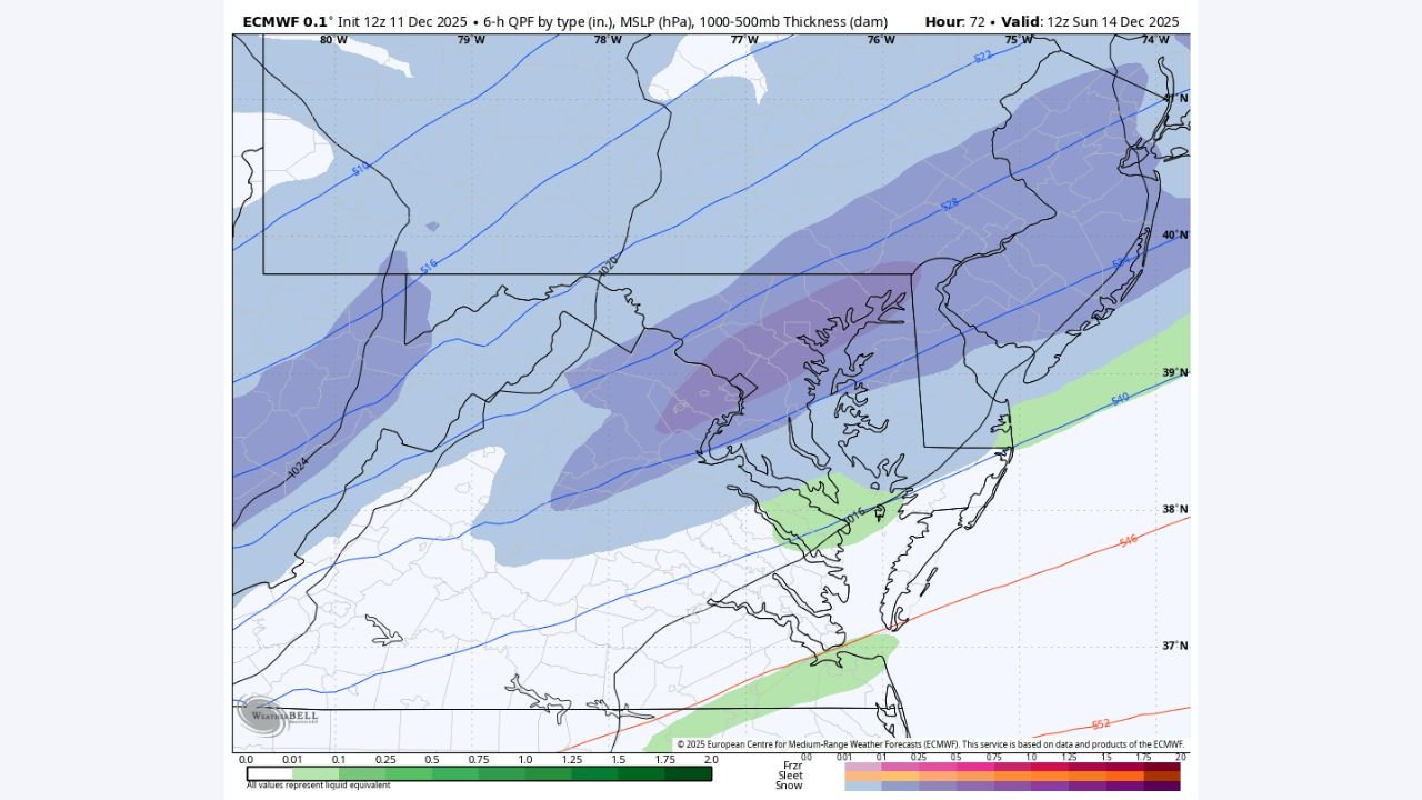
Narrow Snow Zone Sets Up Over the Mid-Atlantic
Latest forecast maps show a band of steady snow stretching from the central Appalachians into the urban corridor, with the heaviest totals lining up close to Baltimore and the northern Chesapeake Bay.
- Areas west of the cities, including portions of western Maryland and the higher elevations, sit on the edge of a broader snow shield.
- Farther east toward the coast, lighter snow or a mix is possible, but the sweet spot for accumulation runs across central Maryland into southern Pennsylvania and parts of New Jersey.
The key detail for residents: this is not a sprawling, all-day Nor’easter, but a focused ribbon of snow that may lay down a quick few inches where it passes overhead.
How Much Snow to Expect
While exact totals will depend on where the band ultimately parks, guidance points to a general 2–4 inches in the favored corridor, with locally higher pockets where the snow holds together longest.
- Cities such as Baltimore and Annapolis sit near the center of that higher-probability zone.
- Surrounding communities in northern Virginia, southern Pennsylvania, and central New Jersey could also see several inches if the band tracks over them.
- Locations just north or south of the corridor may end up with only light accumulations or flurries, underscoring how tight the gradient will be with this system.
In short, this is not a monster winter storm, but it is strong enough to cover roads, sidewalks, and venue parking lots in time for Sunday morning plans.
Timing and Travel Impacts for Sunday
The main window for accumulating snow is early Sunday, from the pre-dawn hours into the morning:
- Snow is expected to develop before or around daybreak in the interior Mid-Atlantic.
- The heaviest burst of snow should occur during the morning, when many people are heading to work, church, or early holiday events.
- By midday, the snow band should be shifting east and weakening, leaving behind slick surfaces and lingering flurries.
Drivers along I-70, I-83, and the I-95 corridor between Washington, D.C., Baltimore, and Philadelphia should be prepared for reduced visibility, slushy lanes, and icy bridges, especially where temperatures hover near freezing.
What It Means for Concerts, Shows, and Holiday Plans
For artists, fans, and crews across the region, this system falls into the category of “small but disruptive.”
- Load-ins and early soundchecks on Sunday morning could be affected by snow-covered side streets and limited parking.
- Evening events are more likely to go on as scheduled, but melt-and-refreeze conditions could make late-night travel slick as temperatures drop again.
- Anyone heading to holiday concerts, church performances, or club shows should plan extra time, check with venues for any schedule adjustments, and dress for cold, damp conditions.
Even if totals stay on the modest side, a well-placed snow band over a major population corridor is enough to slow down the region for several hours.
As the storm approaches and the final track sharpens, ChicagoMusicGuide.com will continue keeping music fans updated on how the weather might affect shows, travel, and holiday plans across the Mid-Atlantic. Stay tuned, stay safe on the roads, and keep an eye on local alerts before you head out to your next gig.