
Michigan Set for Significant December Snowfall as Long-Range ECMWF Model Projects Widespread Accumulations Through December 22
MICHIGAN — New long-range snowfall projections from the ECMWF AIFS model suggest Michigan may be heading into one of its more active December patterns in recent years, with several waves of accumulating snow expected between December 7 and December 22. While extended-range snowfall forecasts carry notable uncertainty, the latest run highlights a consistent trend: multiple systems tracking across the Great Lakes and delivering widespread snowfall totals across much of Michigan.
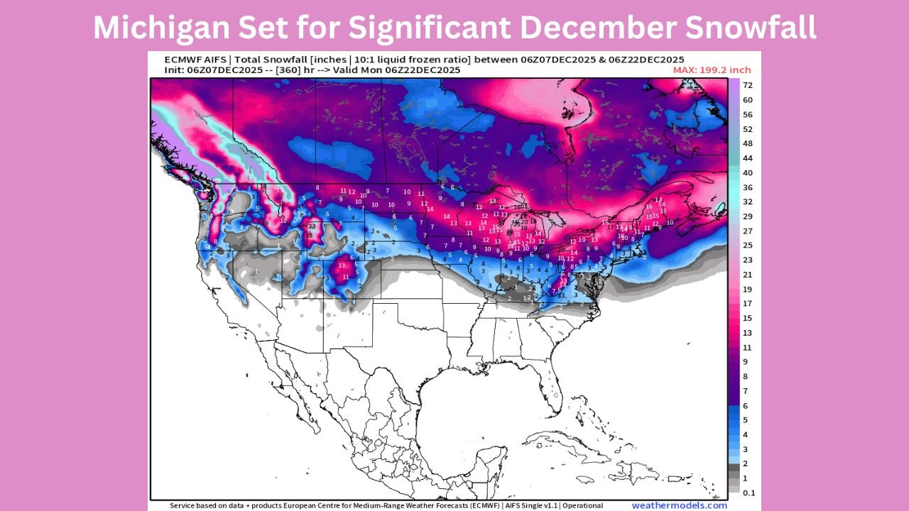
The model, which simulates potential storm tracks and temperature profiles using European weather data, shows a broad swath of 8 to 20 inches of snow across the state over the next two weeks, with the highest totals focused on Northern Michigan, the U.P., and portions of the western Lower Peninsula.
Model Shows a Persistent Snow Corridor Across the Upper Midwest
The ECMWF map illustrates a dominant snow corridor stretching from the Pacific Northwest, across the Northern Plains, and into the Great Lakes. Michigan sits well within this band, where colder air and periodic clipper-type systems are expected to overlap.
Key projections include:
- Upper Peninsula: Widespread totals of 15–22 inches, with localized higher amounts where lake-effect enhancement occurs.
- Northern Lower Michigan: Approximately 8–15 inches across interior counties.
- Western Shoreline Counties: Potential for 10–14 inches, driven partly by periodic lake-effect bursts.
- Southern Michigan: Lower but still notable totals of 3–8 inches, depending on how individual storm tracks evolve.
The snowfall distribution suggests a mix of synoptic systems and lake-effect snow, a combination that typically leads to high-impact travel conditions across the region.
Pattern Driven by Cold Air Return and Frequent Disturbances
While no single blockbuster winter storm is directly indicated in the long-range data, meteorologists note that repeated, moderate systems often produce disruptions comparable to one larger event.
Key atmospheric elements contributing to this pattern:
- A southward dip in the jet stream expected to anchor cold air over the Midwest.
- Clippers streaming out of Canada, each capable of adding a few inches of accumulation.
- Temperature anomalies trending cold enough to support snow for nearly all precipitation events through mid-December.
This aligns with similar trends seen in earlier ensemble forecasts, which have hinted at a colder and more active pattern for the Great Lakes during this period.
Travel Impacts Could Build Over Time
Even with no major blizzard in the forecast window, the cumulative effect of frequent snowfall events can lead to:
- Hazardous roadways
- Reduced visibility during active snow bands
- Compacted snow and ice buildup
- Slower highway travel around Grand Rapids, Lansing, Detroit, and northern tourist regions
Residents planning holiday-season travel should monitor daily forecasts closely, as timing and intensity of individual systems will determine where the biggest impacts occur.
How Uncertain Is a Forecast This Far Out?
Long-range snowfall maps—especially 10–15 days out—are not exact predictors. Instead, they highlight risk zones and probabilistic trends, which in this case clearly favor Michigan for colder air and repeated snow chances.
Meteorologists emphasize that totals will shift as:
- Storm tracks adjust
- Temperature gradients sharpen
- Lake-effect contributions evolve based on wind direction
Still, the persistence of snowfall signals across multiple model runs adds confidence that Michigan is very likely to experience an active stretch of December weather.
Stay Prepared & Stay Informed
Winter weather can change quickly, especially across Michigan. Stay tuned to Chicagomusicguide.com for updated forecasts, travel impacts, and statewide weather alerts throughout the month.