
Midwest Brace for Powerful Arctic Blast as Deep Freeze Targets the Eastern U.S. Next Weekend
INDIANAPOLIS, IN — A Major Arctic Outbreak Could Deliver the Coldest Air of the Season Next Weekend, Indianapolis and much of the Midwest are positioned directly in the path of a strong arctic blast expected to sweep into the Eastern United States next weekend, according to new ECMWF model data released Saturday.
Meteorologists warn that this could be the coldest air mass of the season so far, with widespread morning lows in the 10s and 20s — and even colder wind chills — across Indiana, Kentucky, Ohio, and surrounding states.
Upper-air charts show a deep, sharply carved trough dropping southward from Canada. This setup funnels frigid polar air straight into the Midwest and Ohio Valley, placing central Indiana and Kentucky near the core of the strongest temperature anomalies.
Model Maps Show the Deepest Cold Aimed at the Midwest and Kentucky
500mb height anomaly data highlights a very strong negative anomaly centered across:
- Indiana
- Kentucky
- Ohio
- Tennessee
This atmospheric configuration creates an efficient highway for arctic air, accelerating its push south and east as the weekend approaches.
The severity of the trough suggests the cold snap may be long-lasting rather than a quick overnight freeze.
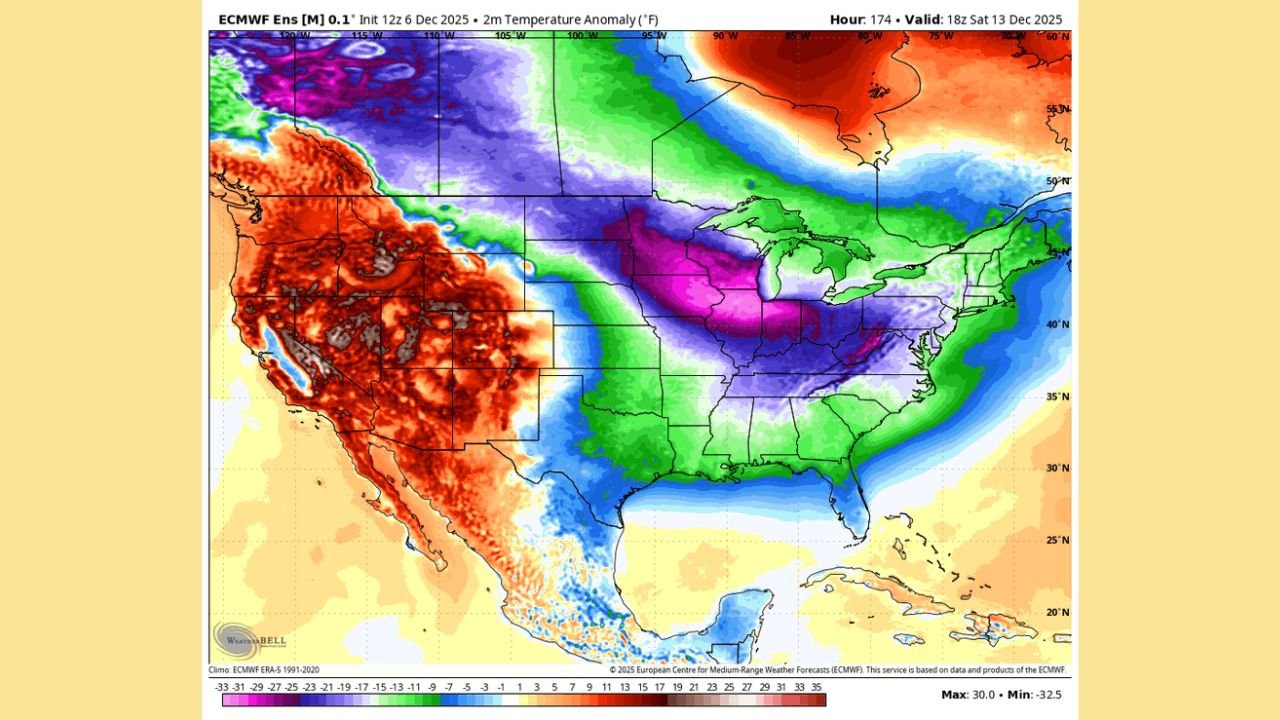
Temperature Anomalies Show the Midwest Up to 20–30°F Below Normal
The ECMWF 2-meter temperature anomaly map for December 13 reveals a large zone of extreme cold centered over Indiana and Kentucky:
- Central Indiana: 20–25°F below average
- Kentucky: 20–30°F below average
- Ohio and Tennessee: 15–25°F below average
- Mid-Atlantic states: 10–20°F below average
The coldest air appears to stretch from Indianapolis through Louisville and into the central Appalachian region, marking the deepest freeze so far this winter.
Snow Possible as Alberta Clipper Swings Through the Midwest
Meteorologists also note a potential Alberta Clipper that could deliver light snow to:
- Indiana
- Illinois
- Ohio
- Michigan
- Northern Kentucky
Impacts from the clipper may include:
- Fast bursts of accumulating snow
- Gusty winds
- Sudden drops in visibility
- Slippery road conditions
For the Southeast, the pattern appears to favor another dry cold surge, with little moisture accompanying the arctic push.
Eastern U.S. Could See Widespread 10s and 20s for Morning Lows
As the cold deepens and spreads outward from Indiana and Kentucky:
- Early-morning freeze conditions could stretch far south
- Wind chills may approach bitter single digits
- Travel between cities may be impacted by minor snow or icy conditions
- Outdoor events and performances may face cold-weather hazards
Cities most likely to experience the sharpest morning lows include:
- Indianapolis
- Louisville
- Lexington
- Cincinnati
- Nashville
- Columbus
- Pittsburgh
What This Means for Music Events, Travel, and Venues
Touring artists, crews, and fans in the Midwest should prepare for:
- Severe early-morning cold during travel days
- Equipment that may be more sensitive to freezing temperatures
- Potential clipper-related travel delays
- Outdoor load-ins becoming more hazardous due to wind chills
Next weekend’s event schedules across Indiana and surrounding states may require additional cold-weather planning.
Model Confidence Is Increasing as Ensembles Align
Meteorologists note strong model agreement across multiple runs, raising confidence that this arctic outbreak will be significant and widespread — especially for Indiana and Kentucky through December 13–15.
ChicagoMusicGuide will continue monitoring updates as new data emerges.
How do you prepare for sudden deep-freeze weather events? Share your thoughts at ChicagoMusicGuide.com!