
Nebraska, Iowa, Illinois, Indiana, Ohio, Pennsylvania, and West Virginia Set for Significant Winter Storm Bringing 2–10 Inches of Snow From Saturday Into Saturday Night
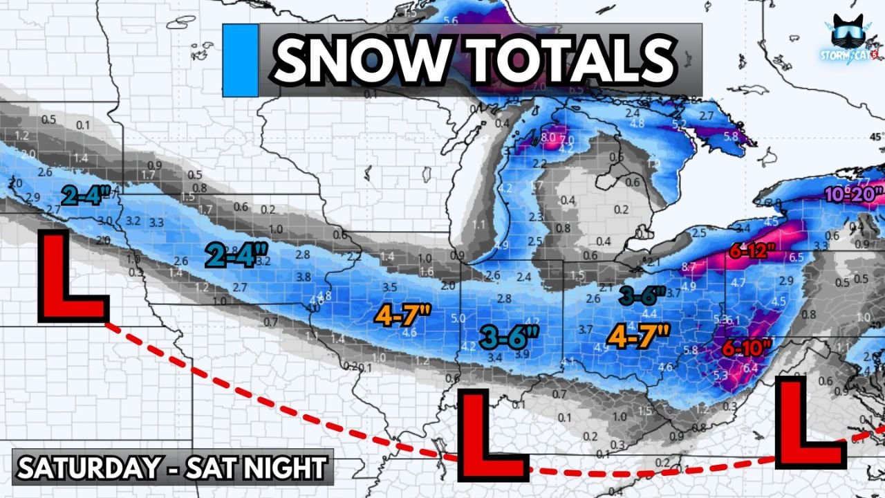
CENTRAL UNITED STATES — A fast-moving winter storm is expected to track from the Central Plains through the Midwest, Ohio Valley, and into the interior Northeast on Saturday, bringing a widespread band of accumulating snow that will impact travel across Nebraska, Iowa, Illinois, Indiana, Ohio, Pennsylvania, and West Virginia. Forecast guidance shows a long corridor of 2–10 inches of snow depending on location, with the heaviest totals developing as the storm strengthens while moving east.
Snow Expands Across the Central Plains and Upper Midwest
Snow will first organize across the Central Plains by early Saturday, spreading from eastern Nebraska through Iowa and into western Illinois.
- Omaha and Lincoln: 2–4 inches
- Des Moines: 2–4 inches, with isolated 4–7 inch pockets
- Peoria and Springfield: 2–4 inches, heavier bands possible
Light to moderate snow combined with cold surface temperatures will allow roads to become snow-covered quickly, especially late morning into midday.
Snow Intensifies Across Indiana and the Ohio Valley
As the storm progresses east, snowfall rates increase through the afternoon and evening across Indiana and the Ohio Valley.
- Indianapolis, Lafayette, Fort Wayne: 3–6 inches, with isolated 4–7 inches
- Bloomington: 3–6 inches
- Columbus, Cincinnati, Louisville: 2–4 inches, highest totals where bands linger longest
Travel conditions will deteriorate rapidly between mid-afternoon and early evening as visibility falls and roads freeze.
Heavier Snow for the Lower Great Lakes and Western Pennsylvania
The storm gains additional moisture as it reaches the Great Lakes region, producing stronger and more persistent snow bands.
- Cleveland, Toledo, Youngstown: 3–6 inches
- Pittsburgh area: 3–6 inches, with potential for slightly higher localized totals
Snowfall rates may briefly reach one inch per hour, leading to slick roads and difficult evening travel.
Interior Northeast and Central Appalachians Face the Highest Totals
As colder air deepens and terrain enhances lift, snowfall totals increase across West Virginia, central Pennsylvania, and interior New York.
- Morgantown and north-central WV: 6–10 inches
- State College region: 6–10 inches, higher amounts possible
- Interior New York: 6–10 inches, locally heavier if banding persists
These areas are most likely to see impactful accumulations and extended delays into Saturday night.
Travel Impacts Expected Across Multiple States
The combination of steady snow, falling temperatures, and increasing wind will create widespread travel issues:
- Snow-covered and icy roads
- Reduced visibility during peak snowfall
- Flight delays possible at regional airports
- Hazardous travel conditions Saturday afternoon through late night
Drivers are advised to adjust plans, reduce speed, and allow extra time.
Arctic Air Follows the Storm
Behind the departing system, a surge of much colder air enters the region Saturday night into Sunday:
- Temperatures drop sharply after midnight
- Wind chills turn dangerous across the Midwest and Ohio Valley
- Quick freeze of untreated roads is likely
This cold push reinforces the pattern shift that has signaled winter’s arrival across much of the central and eastern United States.
Stay Prepared
This storm will impact a large number of states within a short time window. Anyone living in or traveling through the snow corridor from Nebraska to the interior Northeast should remain alert to updated forecasts and local advisories.
Stay Ahead of Winter With ChicagoMusicGuide.com
For more updates on major storms, weather alerts, and regional impacts across the country, follow ChicagoMusicGuide.com as we continue tracking significant winter weather events throughout the season.