
Powerful Thursday Severe Weather Setup Emerging Across Illinois, Indiana and Kentucky as EURO Model Signals Tornado-Capable Supercells
ILLINOIS — A potentially significant severe weather setup is taking shape for Thursday afternoon, February 19, across parts of Illinois, Indiana, and Kentucky, with the latest EURO (ECMWF) guidance highlighting an environment supportive of low-topped supercells capable of all severe hazards — including tornadoes.
Forecast graphics indicate a focused corridor of concern stretching from central and southern Illinois into central Indiana and northern Kentucky, placing cities such as Springfield, Indianapolis, Evansville, Louisville, and Lexington-Fayette within the broader risk zone.
Strong Dynamics Over the Midwest
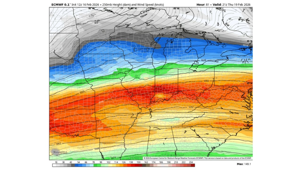
The EURO model depicts a deepening surface low tracking through the Midwest, with a well-defined warm sector expanding northward into Illinois and Indiana. At 250mb, a strong jet streak overspreads the region, signaling enhanced upper-level wind support.
This jet structure is critical. It increases wind shear — both speed and directional shear — which is one of the primary ingredients for rotating thunderstorms. Even with modest instability, this type of wind profile can allow low-topped supercells to develop and sustain rotation.
850mb winds further reinforce the setup, showing a strengthening low-level jet transporting moisture from the Gulf northward into the Ohio Valley. That combination of lift, moisture, and shear is why forecasters are watching this pattern closely.
Instability Sufficient for Severe Storms
CAPE (Convective Available Potential Energy) values on the EURO are not extreme but are sufficient — especially given the strong wind fields. Portions of central and southern Illinois, western and central Indiana, and northern Kentucky show pockets of instability capable of supporting organized thunderstorms.
This is a classic early-season severe weather look for the Midwest:
- Moderate instability
- Strong wind shear
- Deep surface low
- Warm, humid air surging northward
In these environments, storms don’t need towering summer-style instability to become dangerous. Low-topped supercells can quickly spin up brief tornadoes while also producing large hail and damaging straight-line winds.
Timing and Storm Evolution
Current projections favor Thursday afternoon into early evening for the most active period across Illinois and Indiana. Kentucky may see the threat continue into the evening as storms track east and southeast.
Initial development could be more discrete — meaning isolated supercells capable of rotation. Later in the storm cycle, guidance suggests storms may merge into clusters or a line, increasing the potential for widespread 60+ mph wind gusts.
Areas west of the main risk corridor — including parts of Missouri and Iowa — appear to remain on the drier side of the system, while the most favorable overlap of instability and shear aligns across IL, IN, and KY.
What This Means for Chicago
For the Chicago metro area, the setup is more conditional. The strongest parameters appear slightly south of the city, but northern Illinois will still need to be monitored closely.
If the warm sector pushes far enough north, even parts of the Chicago area could see gusty thunderstorms. However, as of now, the more concentrated severe signal favors central and southern Illinois into Indiana.
Bottom Line
The latest EURO guidance paints a very potent Thursday afternoon setup across Illinois, Indiana, and Kentucky, featuring:
- Strong upper-level jet support
- Favorable wind shear
- Sufficient instability for rotating storms
- Risk for tornadoes, hail, and damaging winds
While specifics regarding exact storm mode and placement will be refined in the coming days, this is the type of pattern that warrants close attention across the Midwest.
Chicago Music Guide will continue tracking updates as the forecast evolves. Stay weather-aware and be prepared to act if watches or warnings are issued in your area.