
Texas, Oklahoma, Arkansas, Louisiana, Mississippi, Alabama, and Georgia Could See Severe Weather Threat as Amplified Trough Develops January 8–10
UNITED STATES — Forecast guidance is increasingly focused on a developing amplified upper-level trough that may take shape across the central and southern United States between January 8 and January 10, creating a window where severe weather could become possible if atmospheric conditions align.
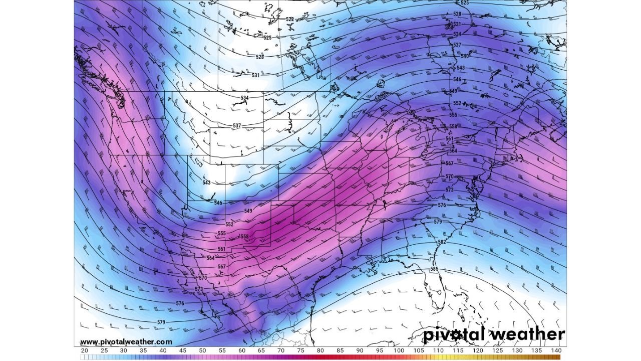
The latest 500-mb height and wind forecasts show a deepening trough digging into the central U.S., with strong mid-level wind energy spreading eastward into the Southern Plains and Lower Mississippi Valley. While confidence remains moderate at this range, meteorologists are closely monitoring how moisture return evolves ahead of this system.
What the Upper-Level Pattern Is Showing
The data indicates a pronounced dip in the jet stream, with stronger wind speeds aloft extending from the Southwest into the central U.S. and toward the Southeast. This type of setup is often associated with enhanced storm organization, particularly if surface-level moisture can move north in time.
At present, wind shear appears sufficient across parts of the South, which is a key ingredient for severe storms. However, moisture availability remains the biggest question mark and will ultimately determine how active this system becomes.
Why Moisture Return Is the Key Limiting Factor
Despite the favorable wind pattern, current projections suggest that Gulf moisture return may initially be limited. Without adequate low-level moisture, thunderstorm development could remain scattered or weak.
That said, even a modest improvement in moisture would significantly increase the risk profile, especially across portions of the Southern Plains, Lower Mississippi Valley, and Southeast. Forecast confidence will improve as the system moves closer and higher-resolution models come into play.
Areas That Could Be Impacted If Conditions Improve
If moisture return strengthens, severe weather potential would increase across multiple southern states, including:
- Texas
- Oklahoma
- Arkansas
- Louisiana
- Mississippi
- Alabama
- Georgia
Possible hazards in this scenario could include strong thunderstorms, damaging winds, and isolated tornadoes, depending on how surface features evolve.
Timeline and What to Watch Next
The January 8–10 timeframe remains the primary window of concern. Over the next several days, forecasters will focus on:
- Strength and placement of the upper-level trough
- Speed of Gulf moisture return
- Development of surface low pressure
- Instability trends across the South
Small changes in any of these factors could dramatically alter the final outcome, ranging from a mostly rain-based system to a more impactful severe weather setup.
What This Means for Travelers and Event Planning
While this system is still several days out, early awareness is important, particularly for anyone with travel plans or outdoor events across the southern U.S. during the second week of January.
Residents in potentially affected states are encouraged to stay weather-aware, especially as forecast confidence increases later this week.
Stay tuned to ChicagoMusicGuide.com for continued weather updates, forecast breakdowns, and real-time coverage as this developing system becomes clearer. If you’re located in the South, let us know your state and how weather changes could impact your plans.