
Upper Peninsula of Michigan Buried by Heavy Snow as Wind-Driven Conditions Disrupt Lower Michigan and Great Lakes Region
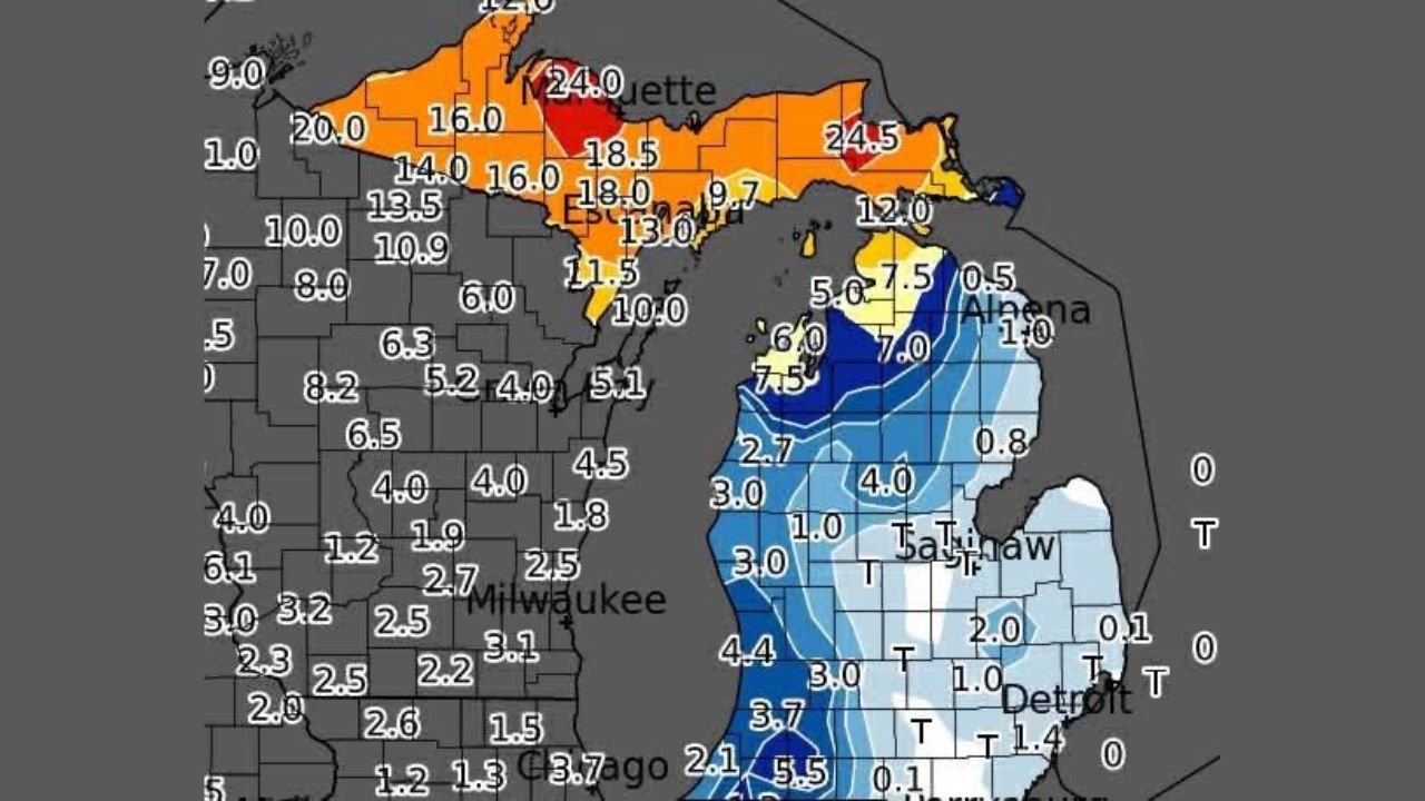
UPPER PENINSULA AND LOWER MICHIGAN — A powerful winter system delivered significant snowfall across Michigan’s Upper Peninsula, while strong winds and lighter accumulations created a chaotic and hazardous day across Lower Michigan and parts of the western Great Lakes. Snowfall totals clearly show the Upper Peninsula as the hardest-hit area, with some locations seeing well over a foot of snow, while conditions farther south were dominated more by wind than snow depth.
The contrast between regions highlights how this storm impacted Michigan in very different ways, depending on location and proximity to Lake Superior and Lake Michigan.
Upper Peninsula Takes the Brunt of the Snowfall
Snowfall data shows the Upper Peninsula of Michigan firmly in the storm’s core. Many areas reported double-digit snow totals, with the north-central and eastern Upper Peninsula seeing some of the highest accumulations.
Lake-enhanced snowfall played a major role, as cold air moving over Lake Superior fueled persistent snow bands. Communities near Marquette and surrounding counties were especially impacted, with snowfall intense enough to significantly reduce visibility and slow travel throughout the day.
Lower Michigan Sees Lower Totals but Hazardous Winds
In Lower Michigan, snowfall totals were noticeably lighter, generally ranging from a trace to a few inches in many locations. However, the storm’s strong winds created dangerous conditions despite the lower accumulations.
Wind-driven snow led to blowing and drifting, particularly in western and central parts of the state. Even areas that received only modest snowfall experienced poor visibility and slick roads, making travel difficult during peak afternoon hours.
Great Lakes Influence Creates Sharp Regional Differences
The storm highlights the powerful influence of the Great Lakes, especially Lake Superior. The Upper Peninsula’s proximity to the lake allowed snow bands to remain locked in place for hours, dramatically increasing totals.
Meanwhile, areas closer to Lake Michigan, including parts of Wisconsin and northern Illinois, saw more modest accumulations. Snowfall amounts generally decreased sharply moving south toward Chicago and Milwaukee, where totals were lighter but still impactful due to wind and cold temperatures.
Why This Storm Was Especially Disruptive
The combination of heavy snow in the Upper Peninsula and strong winds across Lower Michigan created a storm that was disruptive even where snow totals were not extreme. Wind gusts amplified the impact by:
- Reducing visibility during snowfall
- Creating drifting on open roads
- Making conditions feel harsher and more dangerous
This type of setup often leads to travel delays, road closures, and increased accident risk, particularly in rural and lake-adjacent areas.
What Happens Next
While snowfall rates are easing, lingering cold air means snow-covered roads and icy conditions will remain an issue, especially across the Upper Peninsula. Crews will continue cleanup efforts as temperatures stay cold enough to prevent rapid melting.
For travelers, artists, and event planners moving through the Great Lakes region, conditions may remain challenging into the next day, particularly in northern Michigan.
As winter systems continue to move through the Midwest, ChicagoMusicGuide.com will keep tracking how regional weather impacts travel, scheduling, and movement across Michigan and the Great Lakes.