
Washington and Oregon Coastline Watching Weekend Storm Trend Weaken, Though Wind and High Tides Remain a Concern
WASHINGTON – Forecast models continue to suggest that the Saturday–Sunday coastal storm affecting Washington and Oregon is trending weaker, a shift that brings some cautious relief. However, meteorologists stress that even a weaker system can still cause issues because it coincides with very high astronomical tides, meaning wind-driven coastal impacts remain possible despite the downgraded storm strength.
Latest model guidance shows the storm’s central pressure and wind field weakening compared to earlier projections. This reduces the risk of a widespread, high-impact coastal storm, but timing remains unfavorable, as peak onshore flow aligns closely with elevated tide cycles, increasing vulnerability along exposed coastlines.
Why a Weaker Storm Can Still Be a Problem
Although this system is no longer expected to become a major storm, coastal hazards don’t require extreme conditions to develop. When moderate winds overlap with high tides, even brief periods of stronger gusts can lead to:
- Minor coastal flooding
- Beach erosion
- Overtopping of seawalls
- Localized impacts in low-lying coastal areas
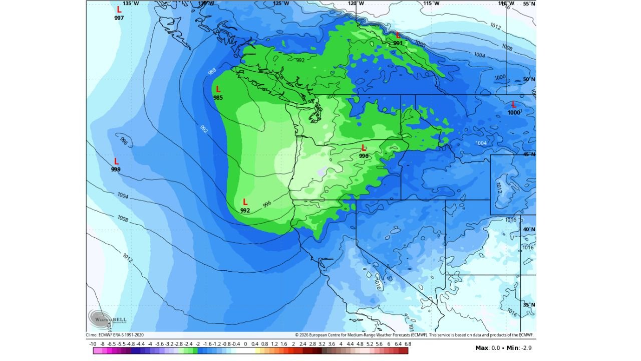
The latest pressure anomaly maps show a broader but less intense low-pressure system, which favors persistent onshore winds rather than damaging storm-force gusts. That setup limits the overall severity but extends the window for potential impacts, especially during high tide cycles.
Model Uncertainty Still High
One key takeaway from the data is that model agreement remains poor. Some guidance shows a quick-moving, weak system with minimal wind response, while others still hint at periodic wind surges along the coast.
This inconsistency is important. Small changes in storm track or timing could mean the difference between a quiet weekend and localized coastal issues, particularly in areas prone to flooding during high tides.
Because of this, forecasters caution against locking in expectations too early. Confidence in exact impacts will improve closer to Saturday, once higher-resolution models resolve the storm’s final structure.
What to Expect This Weekend
Based on current data trends, residents along the Washington and Oregon coastline should expect:
- Breezy to locally windy conditions, especially during onshore flow
- Elevated coastal water levels during high tide periods
- Isolated coastal flooding or splash-over, not widespread damage
- Rapid forecast changes still possible
This is not shaping up to be a major storm, but it also isn’t a system to ignore—particularly for those in coastal or tide-sensitive locations.
Why Forecasters Are Watching Closely
The broader weather pattern shows energy remaining active in the Pacific, which means short-term trends can still shift. Even as this weekend’s system weakens, future coastal disturbances remain possible, making it important to monitor updates beyond just this event.
Forecasters emphasize that impacts will depend heavily on timing, especially whether wind peaks line up with the highest tides. That overlap—not raw storm strength—is the primary concern heading into the weekend.
Final Word
The weakening trend is encouraging, but high tides combined with lingering wind potential mean the Washington and Oregon coastline is not completely in the clear. Conditions should be monitored closely through the end of the week as forecast confidence improves.
Have you noticed increasing coastal impacts during high-tide events, even with weaker storms? Share your observations and stay connected for continued weather updates at ChicagoMusicGuide.com, where we track developing systems and explain what they really mean for communities.