
Washington and Oregon Face Potentially Historic I-5 Corridor Windstorm as Christmas Eve System Brings 45–80 mph Gust Threat
SEATTLE, WASHINGTON — Forecast models are signaling a high-impact windstorm threat along the I-5 corridor in Washington and Oregon, with impacts possible from southern Oregon through western Washington as a rapidly developing low-pressure system tracks northward along the Pacific Coast around Christmas Eve into early Friday. While uncertainty remains high, the potential range of outcomes spans from a strong regional wind event to a rare, potentially historic windstorm capable of widespread power outages and infrastructure damage.
Meteorologists emphasize that this system will require real-time nowcasting, as small changes in the storm’s coastal track could dramatically alter wind impacts across millions of residents.
I-5 Corridor Identified as Primary Impact Zone
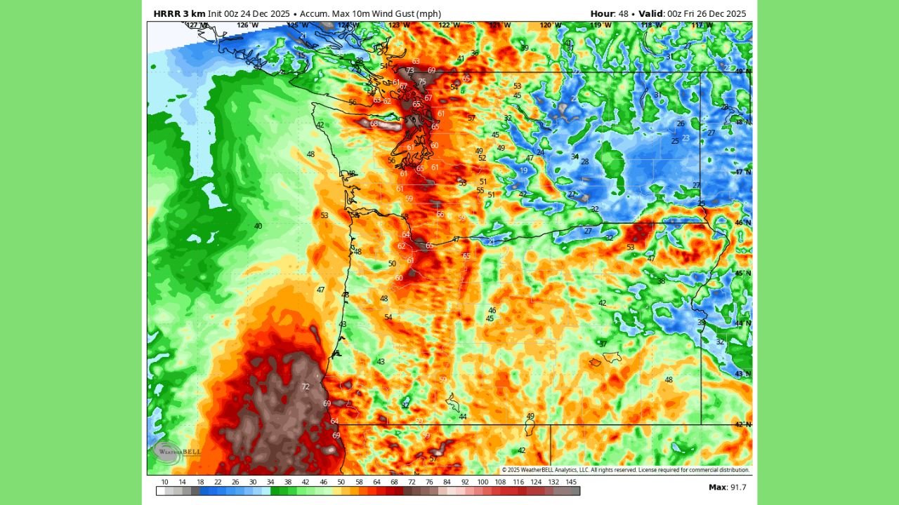
Based on high-resolution HRRR guidance, the I-5 corridor emerges as the most consistently impacted region in current model output. This includes major population centers such as Eugene, Salem, Portland, Olympia, Tacoma, and Seattle, as well as surrounding lowland communities.
At minimum, forecasts suggest a solid wind event with gusts of 45–55 mph along much of the corridor. However, worst-case scenarios depicted in some model runs indicate gusts of 70–80 mph, particularly if the surface low deepens rapidly and tracks just offshore before moving north.
Such wind speeds would be sufficient to down trees, damage structures, and cause widespread power outages, especially in heavily forested western Washington and Oregon.
Why Forecast Confidence Remains Low but Risk Is High
The primary challenge with this system lies in the storm track sensitivity. Forecasters note that a shift of as little as 100 miles east or west in the low-pressure center could result in a dramatically different outcome.
Some guidance, including recent NAM model trends, has backed the low closer to the coastline, which would reduce wind intensity inland. Other guidance, such as earlier HRRR runs, shows a more aggressive scenario with intense pressure gradients driving extreme winds directly into the I-5 corridor.
This wide spread in solutions explains why confidence remains low, yet concern remains elevated.
Timing: When the Strongest Winds Could Occur
Current projections place the highest risk window from late Christmas Eve through the overnight hours into early Friday morning. Winds would increase rapidly as the low strengthens and moves northward, potentially leaving little time for last-minute preparation.
Because the storm develops quickly, warning lead times may be short, making early awareness and preparation especially important for residents and travelers.
Potential Impacts if Worst-Case Scenario Develops
If the storm tracks favorably for stronger winds, impacts could include:
- Widespread power outages, potentially affecting hundreds of thousands to millions of customers
- Downed trees and power lines, especially in saturated soils
- Hazardous travel on north–south routes, including bridges and exposed roadways
- Coastal impacts, including rough seas and localized coastal damage
Forecasters stress that while a historic outcome is not guaranteed, it remains a legitimate possibility, which is why officials urge preparedness without panic.
What Residents Should Do Now
Emergency planners and meteorologists advise residents across western Washington and Oregon to take precautionary steps:
- Secure outdoor decorations and loose items
- Prepare for possible extended power outages
- Charge essential devices ahead of time
- Avoid unnecessary travel during peak wind hours
Updates are expected as forecasters gain clarity on the storm’s exact evolution.
A High-Stakes Christmas Eve Forecast
This system represents one of the more stressful forecast scenarios meteorologists face, balancing uncertainty with the responsibility to communicate potential high-impact risk. While the storm could ultimately resemble a typical winter wind event, the possibility of a once-in-a-generation windstorm cannot be dismissed at this stage.
As western Washington and Oregon head into the holiday period, staying informed will be critical. For continued updates on Pacific Northwest weather threats, windstorm forecasts, and travel safety information, visit ChicagoMusicGuide.com.