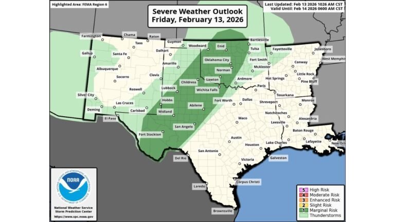
Mississippi, Arkansas, Tennessee, Kentucky, and Ohio Face Marginal Severe Weather Risk as Storm System Tracks From Lower Mississippi Valley to Ohio Valley
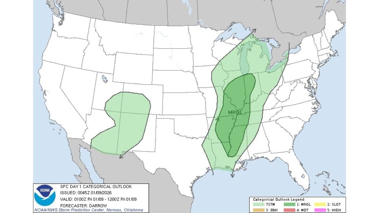
MISSISSIPPI — A broad but organized storm system is expected to move from the lower Mississippi Valley into the Ohio Valley on Friday, placing multiple states under a marginal risk for severe weather, according to the latest SPC Day 1 Outlook. While this is not a high-end outbreak scenario, conditions will support pockets of strong storms, heavy rainfall, and localized impacts across a wide region.
States Included in the Marginal Risk Zone
Based on the outlook map, the primary area of concern stretches north-northeast from the Gulf Coast into the Midwest, affecting:
- Mississippi
- Arkansas
- Tennessee
- Kentucky
- Ohio
- Parts of Louisiana, Indiana, and southern Michigan
This risk corridor aligns closely with the Ohio Valley transition zone, where warm, moist air from the south collides with cooler air to the north.
What “Marginal Risk” Means for Residents
A marginal risk does not guarantee severe weather everywhere, but it does signal that:
- Isolated severe thunderstorms are possible
- Strong wind gusts could occur in heavier cells
- Brief heavy rainfall may lead to localized flooding issues
- A few storms may become stronger than anticipated, especially where instability increases
For cities such as Jackson (MS), Memphis (TN), Louisville (KY), and Cincinnati (OH), impacts will depend heavily on timing, cloud cover, and how quickly storms organize.
Why This Setup Matters Meteorologically
The storm system is driven by a positively tilted upper-level trough, a configuration that allows deep Gulf moisture to stream northward. Forecast data shows:
- Rising dew points, supporting storm development
- Increasing wind shear, particularly from Arkansas into Tennessee and Kentucky
- A broad swath of lift ahead of a cold front pushing eastward
While instability may be limited in some areas, any breaks in cloud cover could allow storms to strengthen quickly, especially Friday afternoon into the evening.
Rainfall and Flooding Concerns
In addition to wind threats, repeated rounds of rain could affect parts of:
- Northern Mississippi
- Western Tennessee
- Southern Kentucky
Although widespread flooding is not expected, urban and low-lying areas could see brief water accumulation during heavier downpours.
What to Watch Going Into Friday
Forecasters are closely monitoring:
- Storm timing (morning rain vs. afternoon redevelopment)
- Temperature rebounds, especially if highs climb toward the upper 60s or near 70°F in southern areas
- Storm clustering, which could enhance wind potential
Confidence will increase as higher-resolution models refine the setup closer to Friday.
Bottom Line
From Mississippi through the Ohio Valley, Friday’s weather setup favors scattered strong storms rather than widespread severe weather. Still, residents should stay alert, especially during the afternoon and evening hours, as conditions could briefly intensify in localized areas.
Stay weather-aware and check updated forecasts before heading out.
What are you seeing in your area — rain, wind, or clearing skies? Share your local conditions and follow ongoing weather coverage at ChicagoMusicGuide.com.