
Washington, Oregon, and Northern California Forecast to Be the Wettest Regions on Earth This Week as Atmospheric River Slams the Pacific Northwest
PACIFIC NORTHWEST — A powerful stretch of storms is setting up to deliver some of the heaviest rainfall on the planet over the next six days, with new model data showing Washington, Oregon, and Northern California facing extreme precipitation totals as a deep atmospheric river takes aim at the coast.
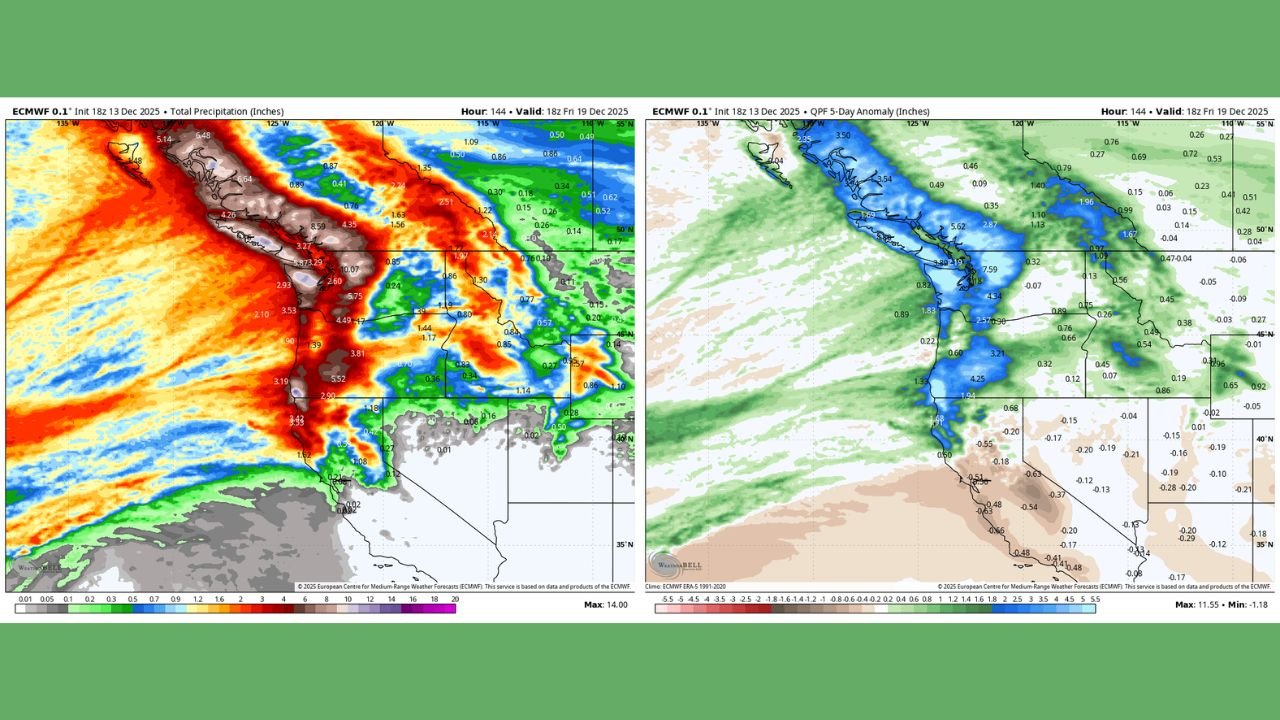
Forecast maps show 5–10+ inches of rain likely across the Olympic Peninsula, Washington Cascades, northwestern Oregon, and far Northern California — with some higher peaks potentially receiving over a foot of precipitation. These totals place the region among the wettest locations in the world outside of the Tropics this week.
A Major Atmospheric River Setup Takes Aim at the Coast
High-resolution ECMWF data highlights a powerful plume of Pacific moisture slamming into the Northwest, with rainfall anomalies far above normal:
- Western Washington: Widespread 6–10+ inches
- Northwestern Oregon: 4–8 inches
- Northern California coast & mountains: 3–7 inches
- Interior Oregon/Idaho mountains: 1–4 inches
- Southern California & Nevada: Mostly lighter totals under 1 inch
The QPF anomaly maps also suggest totals running 300–500% above average across key mountain ranges — the type of setup that historically leads to flooding concerns, rapid river rises, and landslide potential.
Heaviest Rainfall Expected Through Friday
Model projections highlight a persistent, long-duration event:
- Multiple waves of moisture arriving from Saturday through Friday
- Near-constant rainfall for coastal Washington and Oregon
- Strong orographic lift enhancing totals in higher terrain
- Snow levels rising at times, reducing snowpack retention and increasing runoff
The total precipitation map shows a concentrated firehose of moisture pointed squarely at the Northwest coastline — classic atmospheric river behavior.
Flooding, Landslides, and Travel Impacts Likely
With such extreme rain rates and multi-day totals:
- Urban flooding is possible in low-lying areas
- River levels may rise rapidly — especially in Western Washington
- Landslides and mudslides become increasingly likely in saturated hillsides
- High-elevation snow could transition to rain at times, boosting runoff
Residents should monitor local alerts as the event advances.
Why the Pacific Northwest Is Being Targeted
Meteorologists note several key drivers behind this extraordinary wet pattern:
- A strong Pacific jet stream aligned directly into the Northwest
- Warm ocean waters feeding the moisture plume
- Repeated storm impulses reinforcing the atmospheric river
- Persistent onshore flow preventing breaks between systems
Taken together, these factors create a setup capable of producing some of the highest rainfall totals globally this week.
What Happens After the Atmospheric River?
Forecast models hint at a brief drying trend by late next weekend, but the pattern remains active. Additional moisture surges could return before the end of December, potentially keeping the Northwest in a prolonged storm cycle.
Stay Prepared
The Pacific Northwest experiences heavy winter rainfall every year — but this week’s setup is exceptional even by local standards.
Residents in Washington, Oregon, and Northern California should:
- Watch for updated flood alerts
- Avoid driving through flooded roads
- Prepare for potential power outages
- Stay aware of changing travel conditions in mountain passes
Stay Weather-Ready with ChicagoMusicGuide.com
If you live in an area prone to heavy rain, floods, or winter storms, stay connected with ChicagoMusicGuide.com for continuing coverage, forecast updates, and real-time weather insights throughout the season.